You are here: Home > Network List > AK - Alaska Regional Network Stations List
> Station WAT5 Susitna Watana 5, AK, USA > Earthquake Result Viewer
WAT5 Susitna Watana 5, AK, USA - Earthquake Result Viewer
| Earthquake location: |
Bonin Islands, Japan Region |
| Earthquake latitude/longitude: |
28.4/138.9 |
| Earthquake time(UTC): |
2014/06/30 (181) 19:55:32 GMT |
| Earthquake Depth: |
512 km |
| Earthquake Magnitude: |
6.2 MWB |
| Earthquake Catalog/Contributor: |
NEIC PDE/NEIC COMCAT |
|
| Network: |
AK Alaska Regional Network |
| Station: |
WAT5 Susitna Watana 5, AK, USA |
| Lat/Lon: |
63.06 N/148.23 W |
| Elevation: |
1691 m |
|
| Distance: |
57.4 deg |
| Az: |
31.109 deg |
| Baz: |
268.949 deg |
| Ray Param: |
0.061462328 |
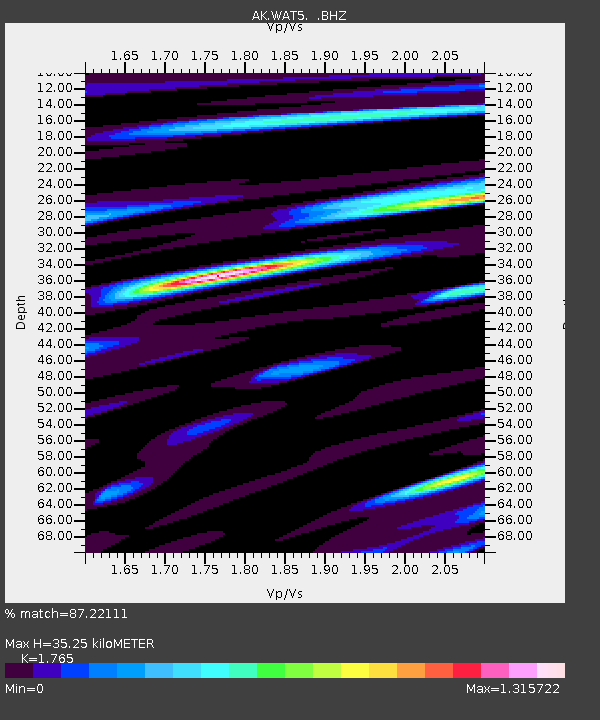
| Estimated Moho Depth: |
35.25 km |
| Estimated Crust Vp/Vs: |
1.76 |
| Assumed Crust Vp: |
6.566 km/s |
| Estimated Crust Vs: |
3.72 km/s |
| Estimated Crust Poisson's Ratio: |
0.26 |
|
| Radial Match: |
87.22111 % |
| Radial Bump: |
400 |
| Transverse Match: |
80.1101 % |
| Transverse Bump: |
346 |
| SOD ConfigId: |
751272 |
| Insert Time: |
2014-07-14 20:15:48.592 +0000 |
| GWidth: |
2.5 |
| Max Bumps: |
400 |
| Tol: |
0.001 |
|

Signal To Noise
| Channel | StoN | STA | LTA |
| AK:WAT5: :BHZ:20140630T20:04:01.027987Z | 23.34027 | 1.9774254E-6 | 8.472162E-8 |
| AK:WAT5: :BHN:20140630T20:04:01.027987Z | 2.647684 | 2.5141443E-7 | 9.4956356E-8 |
| AK:WAT5: :BHE:20140630T20:04:01.027987Z | 13.102048 | 9.1706204E-7 | 6.9993796E-8 |
| Arrivals |
| Ps | 4.3 SECOND |
| PpPs | 14 SECOND |
| PsPs/PpSs | 18 SECOND |


