You are here: Home > Network List > AV - Alaska Volcano Observatory Stations List
> Station AMKA Regional Station, Amchitka Island, Alaska > Earthquake Result Viewer
AMKA Regional Station, Amchitka Island, Alaska - Earthquake Result Viewer
| Earthquake location: |
Bonin Islands, Japan Region |
| Earthquake latitude/longitude: |
28.4/138.9 |
| Earthquake time(UTC): |
2014/06/30 (181) 19:55:32 GMT |
| Earthquake Depth: |
512 km |
| Earthquake Magnitude: |
6.2 MWB |
| Earthquake Catalog/Contributor: |
NEIC PDE/NEIC COMCAT |
|
| Network: |
AV Alaska Volcano Observatory |
| Station: |
AMKA Regional Station, Amchitka Island, Alaska |
| Lat/Lon: |
51.38 N/179.30 E |
| Elevation: |
116 m |
|
| Distance: |
37.9 deg |
| Az: |
41.38 deg |
| Baz: |
248.376 deg |
| Ray Param: |
0.073349 |
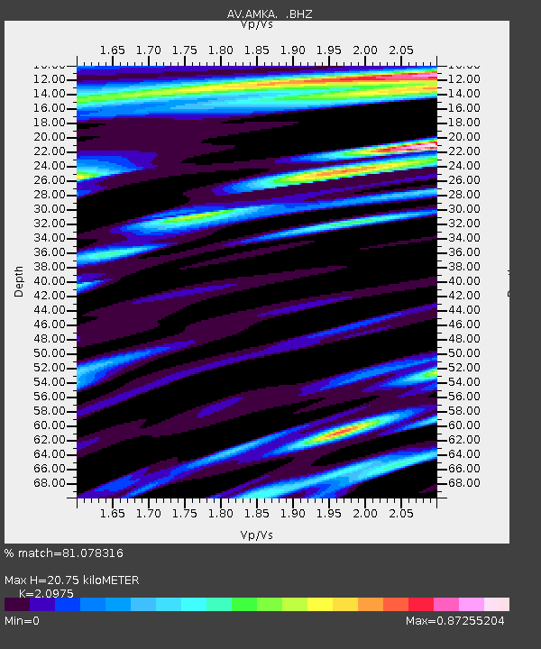
| Estimated Moho Depth: |
20.75 km |
| Estimated Crust Vp/Vs: |
2.10 |
| Assumed Crust Vp: |
6.183 km/s |
| Estimated Crust Vs: |
2.948 km/s |
| Estimated Crust Poisson's Ratio: |
0.35 |
|
| Radial Match: |
81.078316 % |
| Radial Bump: |
400 |
| Transverse Match: |
79.37069 % |
| Transverse Bump: |
400 |
| SOD ConfigId: |
751272 |
| Insert Time: |
2014-07-14 20:19:41.228 +0000 |
| GWidth: |
2.5 |
| Max Bumps: |
400 |
| Tol: |
0.001 |
|
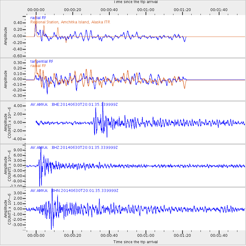
Signal To Noise
| Channel | StoN | STA | LTA |
| AV:AMKA: :BHZ:20140630T20:01:35.339999Z | 22.772959 | 4.285376E-6 | 1.8817826E-7 |
| AV:AMKA: :BHN:20140630T20:01:35.339999Z | 2.5681727 | 4.0217878E-7 | 1.5660115E-7 |
| AV:AMKA: :BHE:20140630T20:01:35.339999Z | 6.3242364 | 1.1878601E-6 | 1.8782664E-7 |
| Arrivals |
| Ps | 3.9 SECOND |
| PpPs | 9.9 SECOND |
| PsPs/PpSs | 14 SECOND |


