You are here: Home > Network List > TA - USArray Transportable Network (new EarthScope stations) Stations List
> Station A36M Sachs Harbour, NT, CAN > Earthquake Result Viewer
A36M Sachs Harbour, NT, CAN - Earthquake Result Viewer
| Earthquake location: |
Bonin Islands, Japan Region |
| Earthquake latitude/longitude: |
28.4/138.9 |
| Earthquake time(UTC): |
2014/06/30 (181) 19:55:32 GMT |
| Earthquake Depth: |
512 km |
| Earthquake Magnitude: |
6.2 MWB |
| Earthquake Catalog/Contributor: |
NEIC PDE/NEIC COMCAT |
|
| Network: |
TA USArray Transportable Network (new EarthScope stations) |
| Station: |
A36M Sachs Harbour, NT, CAN |
| Lat/Lon: |
71.99 N/125.25 W |
| Elevation: |
32 m |
|
| Distance: |
65.1 deg |
| Az: |
19.947 deg |
| Baz: |
284.879 deg |
| Ray Param: |
0.056655157 |
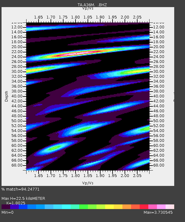
| Estimated Moho Depth: |
22.5 km |
| Estimated Crust Vp/Vs: |
1.80 |
| Assumed Crust Vp: |
6.24 km/s |
| Estimated Crust Vs: |
3.462 km/s |
| Estimated Crust Poisson's Ratio: |
0.28 |
|
| Radial Match: |
94.24771 % |
| Radial Bump: |
400 |
| Transverse Match: |
89.187256 % |
| Transverse Bump: |
400 |
| SOD ConfigId: |
751272 |
| Insert Time: |
2014-07-14 20:43:27.578 +0000 |
| GWidth: |
2.5 |
| Max Bumps: |
400 |
| Tol: |
0.001 |
|

Signal To Noise
| Channel | StoN | STA | LTA |
| TA:A36M: :BHZ:20140630T20:04:51.42499Z | 34.421467 | 2.429251E-6 | 7.057372E-8 |
| TA:A36M: :BHN:20140630T20:04:51.42499Z | 5.1400547 | 3.3761597E-7 | 6.568334E-8 |
| TA:A36M: :BHE:20140630T20:04:51.42499Z | 14.05815 | 6.7642304E-7 | 4.8116075E-8 |
| Arrivals |
| Ps | 3.0 SECOND |
| PpPs | 9.7 SECOND |
| PsPs/PpSs | 13 SECOND |


