You are here: Home > Network List > TA - USArray Transportable Network (new EarthScope stations) Stations List
> Station L04D Klamath Falls, OR, USA > Earthquake Result Viewer
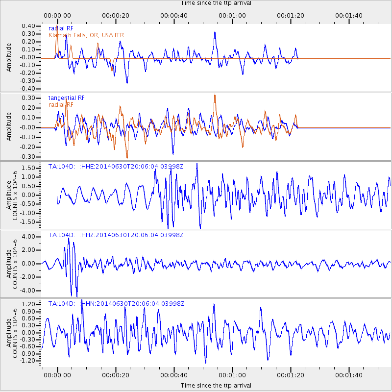
L04D Klamath Falls, OR, USA - Earthquake Result Viewer
*The percent match for this event was below the threshold and hence no stack was calculated.
| Earthquake location: |
Bonin Islands, Japan Region |
| Earthquake latitude/longitude: |
28.4/138.9 |
| Earthquake time(UTC): |
2014/06/30 (181) 19:55:32 GMT |
| Earthquake Depth: |
512 km |
| Earthquake Magnitude: |
6.2 MWB |
| Earthquake Catalog/Contributor: |
NEIC PDE/NEIC COMCAT |
|
| Network: |
TA USArray Transportable Network (new EarthScope stations) |
| Station: |
L04D Klamath Falls, OR, USA |
| Lat/Lon: |
42.22 N/122.30 W |
| Elevation: |
1437 m |
|
| Distance: |
77.5 deg |
| Az: |
48.741 deg |
| Baz: |
296.884 deg |
| Ray Param: |
$rayparam |
*The percent match for this event was below the threshold and hence was not used in the summary stack. |
|
| Radial Match: |
58.828106 % |
| Radial Bump: |
321 |
| Transverse Match: |
60.944756 % |
| Transverse Bump: |
400 |
| SOD ConfigId: |
751272 |
| Insert Time: |
2014-07-14 20:45:33.181 +0000 |
| GWidth: |
2.5 |
| Max Bumps: |
400 |
| Tol: |
0.001 |
|
Signal To Noise
| Channel | StoN | STA | LTA |
| TA:L04D: :HHZ:20140630T20:06:04.03998Z | 7.2924576 | 1.6866168E-6 | 2.3128236E-7 |
| TA:L04D: :HHN:20140630T20:06:04.03998Z | 1.0192602 | 3.6656672E-7 | 3.5963998E-7 |
| TA:L04D: :HHE:20140630T20:06:04.03998Z | 2.0888164 | 6.426379E-7 | 3.0765648E-7 |
| Arrivals |
| Ps | |
| PpPs | |
| PsPs/PpSs | |


