You are here: Home > Network List > TA - USArray Transportable Network (new EarthScope stations) Stations List
> Station MSTX Muleshoe, TX, USA > Earthquake Result Viewer
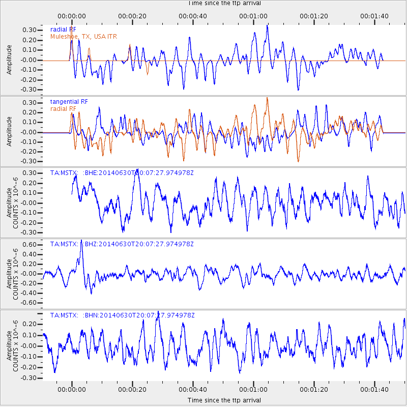
MSTX Muleshoe, TX, USA - Earthquake Result Viewer
*The percent match for this event was below the threshold and hence no stack was calculated.
| Earthquake location: |
Bonin Islands, Japan Region |
| Earthquake latitude/longitude: |
28.4/138.9 |
| Earthquake time(UTC): |
2014/06/30 (181) 19:55:32 GMT |
| Earthquake Depth: |
512 km |
| Earthquake Magnitude: |
6.2 MWB |
| Earthquake Catalog/Contributor: |
NEIC PDE/NEIC COMCAT |
|
| Network: |
TA USArray Transportable Network (new EarthScope stations) |
| Station: |
MSTX Muleshoe, TX, USA |
| Lat/Lon: |
33.97 N/102.77 W |
| Elevation: |
1167 m |
|
| Distance: |
94.9 deg |
| Az: |
47.22 deg |
| Baz: |
308.887 deg |
| Ray Param: |
$rayparam |
*The percent match for this event was below the threshold and hence was not used in the summary stack. |
|
| Radial Match: |
45.52552 % |
| Radial Bump: |
400 |
| Transverse Match: |
53.32211 % |
| Transverse Bump: |
400 |
| SOD ConfigId: |
751272 |
| Insert Time: |
2014-07-14 20:45:48.230 +0000 |
| GWidth: |
2.5 |
| Max Bumps: |
400 |
| Tol: |
0.001 |
|
Signal To Noise
| Channel | StoN | STA | LTA |
| TA:MSTX: :BHZ:20140630T20:07:27.974978Z | 2.9294043 | 2.8226196E-7 | 9.6354725E-8 |
| TA:MSTX: :BHN:20140630T20:07:27.974978Z | 0.6630529 | 7.881523E-8 | 1.1886718E-7 |
| TA:MSTX: :BHE:20140630T20:07:27.974978Z | 0.86282074 | 1.2681728E-7 | 1.4697987E-7 |
| Arrivals |
| Ps | |
| PpPs | |
| PsPs/PpSs | |


