You are here: Home > Network List > US - United States National Seismic Network Stations List
> Station DGMT Dagmar, Montana, USA > Earthquake Result Viewer
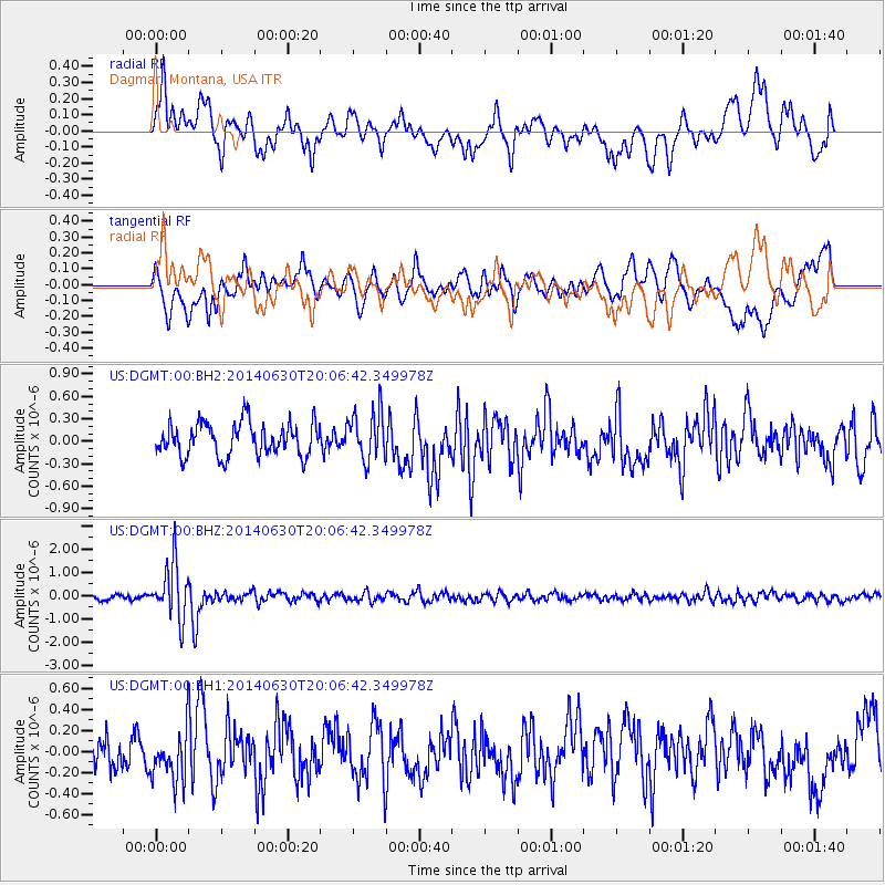
DGMT Dagmar, Montana, USA - Earthquake Result Viewer
*The percent match for this event was below the threshold and hence no stack was calculated.
| Earthquake location: |
Bonin Islands, Japan Region |
| Earthquake latitude/longitude: |
28.4/138.9 |
| Earthquake time(UTC): |
2014/06/30 (181) 19:55:32 GMT |
| Earthquake Depth: |
512 km |
| Earthquake Magnitude: |
6.2 MWB |
| Earthquake Catalog/Contributor: |
NEIC PDE/NEIC COMCAT |
|
| Network: |
US United States National Seismic Network |
| Station: |
DGMT Dagmar, Montana, USA |
| Lat/Lon: |
48.47 N/104.20 W |
| Elevation: |
0.0 m |
|
| Distance: |
85.0 deg |
| Az: |
36.551 deg |
| Baz: |
307.936 deg |
| Ray Param: |
$rayparam |
*The percent match for this event was below the threshold and hence was not used in the summary stack. |
|
| Radial Match: |
70.51139 % |
| Radial Bump: |
400 |
| Transverse Match: |
65.84089 % |
| Transverse Bump: |
400 |
| SOD ConfigId: |
751272 |
| Insert Time: |
2014-07-14 20:47:54.251 +0000 |
| GWidth: |
2.5 |
| Max Bumps: |
400 |
| Tol: |
0.001 |
|
Signal To Noise
| Channel | StoN | STA | LTA |
| US:DGMT:00:BHZ:20140630T20:06:42.349978Z | 11.323298 | 1.1854895E-6 | 1.0469472E-7 |
| US:DGMT:00:BH1:20140630T20:06:42.349978Z | 1.2353811 | 2.3776603E-7 | 1.924637E-7 |
| US:DGMT:00:BH2:20140630T20:06:42.349978Z | 1.4858592 | 3.2728673E-7 | 2.2026767E-7 |
| Arrivals |
| Ps | |
| PpPs | |
| PsPs/PpSs | |


