You are here: Home > Network List > US - United States National Seismic Network Stations List
> Station MSO Missoula, Montana, USA > Earthquake Result Viewer
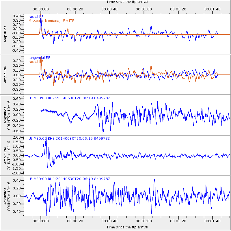
MSO Missoula, Montana, USA - Earthquake Result Viewer
*The percent match for this event was below the threshold and hence no stack was calculated.
| Earthquake location: |
Bonin Islands, Japan Region |
| Earthquake latitude/longitude: |
28.4/138.9 |
| Earthquake time(UTC): |
2014/06/30 (181) 19:55:32 GMT |
| Earthquake Depth: |
512 km |
| Earthquake Magnitude: |
6.2 MWB |
| Earthquake Catalog/Contributor: |
NEIC PDE/NEIC COMCAT |
|
| Network: |
US United States National Seismic Network |
| Station: |
MSO Missoula, Montana, USA |
| Lat/Lon: |
46.83 N/113.94 W |
| Elevation: |
1264 m |
|
| Distance: |
80.5 deg |
| Az: |
41.682 deg |
| Baz: |
301.394 deg |
| Ray Param: |
$rayparam |
*The percent match for this event was below the threshold and hence was not used in the summary stack. |
|
| Radial Match: |
67.51039 % |
| Radial Bump: |
400 |
| Transverse Match: |
54.723896 % |
| Transverse Bump: |
400 |
| SOD ConfigId: |
751272 |
| Insert Time: |
2014-07-14 20:48:53.558 +0000 |
| GWidth: |
2.5 |
| Max Bumps: |
400 |
| Tol: |
0.001 |
|
Signal To Noise
| Channel | StoN | STA | LTA |
| US:MSO:00:BHZ:20140630T20:06:19.849978Z | 8.847393 | 8.7828505E-7 | 9.927049E-8 |
| US:MSO:00:BH1:20140630T20:06:19.849978Z | 2.5674777 | 1.7209884E-7 | 6.7030314E-8 |
| US:MSO:00:BH2:20140630T20:06:19.849978Z | 1.5085386 | 1.9359453E-7 | 1.283325E-7 |
| Arrivals |
| Ps | |
| PpPs | |
| PsPs/PpSs | |


