You are here: Home > Network List > UW - Pacific Northwest Regional Seismic Network Stations List
> Station MRBL Marblemount, WA, USA > Earthquake Result Viewer
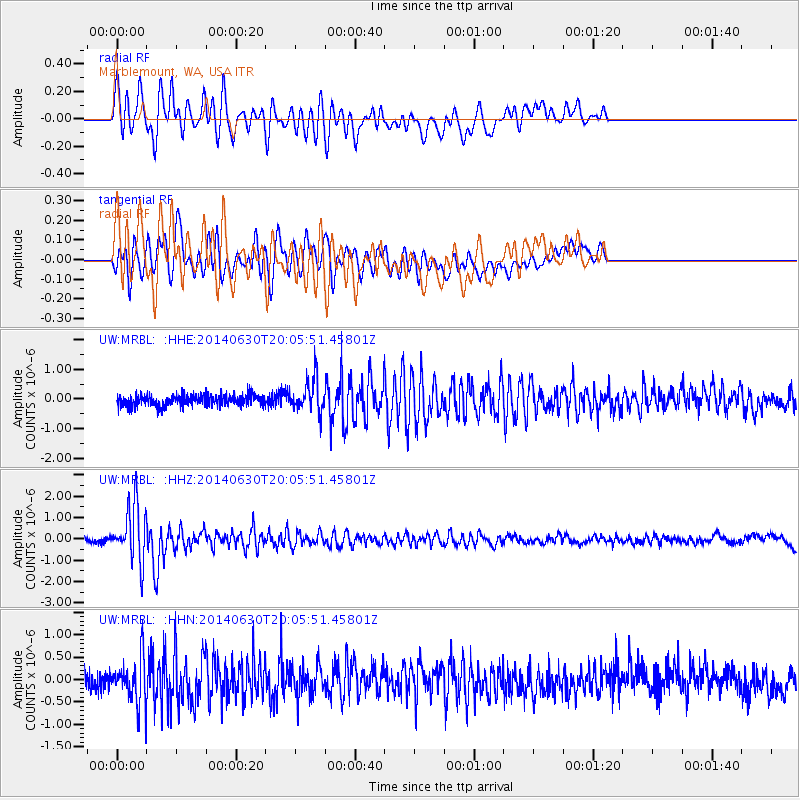
MRBL Marblemount, WA, USA - Earthquake Result Viewer
*The percent match for this event was below the threshold and hence no stack was calculated.
| Earthquake location: |
Bonin Islands, Japan Region |
| Earthquake latitude/longitude: |
28.4/138.9 |
| Earthquake time(UTC): |
2014/06/30 (181) 19:55:32 GMT |
| Earthquake Depth: |
512 km |
| Earthquake Magnitude: |
6.2 MWB |
| Earthquake Catalog/Contributor: |
NEIC PDE/NEIC COMCAT |
|
| Network: |
UW Pacific Northwest Regional Seismic Network |
| Station: |
MRBL Marblemount, WA, USA |
| Lat/Lon: |
48.52 N/121.48 W |
| Elevation: |
75 m |
|
| Distance: |
75.2 deg |
| Az: |
42.673 deg |
| Baz: |
296.038 deg |
| Ray Param: |
$rayparam |
*The percent match for this event was below the threshold and hence was not used in the summary stack. |
|
| Radial Match: |
74.891235 % |
| Radial Bump: |
400 |
| Transverse Match: |
69.493996 % |
| Transverse Bump: |
400 |
| SOD ConfigId: |
751272 |
| Insert Time: |
2014-07-14 20:52:26.400 +0000 |
| GWidth: |
2.5 |
| Max Bumps: |
400 |
| Tol: |
0.001 |
|
Signal To Noise
| Channel | StoN | STA | LTA |
| UW:MRBL: :HHZ:20140630T20:05:51.45801Z | 14.85226 | 1.3177613E-6 | 8.872464E-8 |
| UW:MRBL: :HHN:20140630T20:05:51.45801Z | 2.485932 | 4.8145904E-7 | 1.9367344E-7 |
| UW:MRBL: :HHE:20140630T20:05:51.45801Z | 2.9610357 | 5.6130676E-7 | 1.8956432E-7 |
| Arrivals |
| Ps | |
| PpPs | |
| PsPs/PpSs | |


