You are here: Home > Network List > TA - USArray Transportable Network (new EarthScope stations) Stations List
> Station O48A Farmland, IN, USA > Earthquake Result Viewer
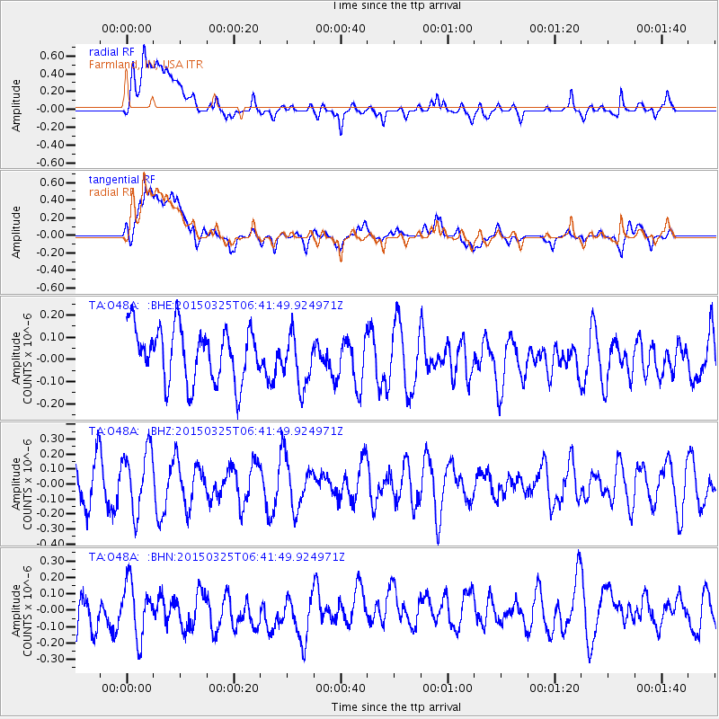
O48A Farmland, IN, USA - Earthquake Result Viewer
*The percent match for this event was below the threshold and hence no stack was calculated.
| Earthquake location: |
Hokkaido, Japan Region |
| Earthquake latitude/longitude: |
43.7/145.9 |
| Earthquake time(UTC): |
2015/03/25 (084) 06:30:01 GMT |
| Earthquake Depth: |
120 km |
| Earthquake Magnitude: |
4.3 mb, 4.3 mb |
| Earthquake Catalog/Contributor: |
ISC/ISC |
|
| Network: |
TA USArray Transportable Network (new EarthScope stations) |
| Station: |
O48A Farmland, IN, USA |
| Lat/Lon: |
40.26 N/85.16 W |
| Elevation: |
300 m |
|
| Distance: |
84.6 deg |
| Az: |
36.733 deg |
| Baz: |
325.463 deg |
| Ray Param: |
$rayparam |
*The percent match for this event was below the threshold and hence was not used in the summary stack. |
|
| Radial Match: |
49.10183 % |
| Radial Bump: |
400 |
| Transverse Match: |
50.565956 % |
| Transverse Bump: |
400 |
| SOD ConfigId: |
7422571 |
| Insert Time: |
2019-04-17 22:04:22.835 +0000 |
| GWidth: |
2.5 |
| Max Bumps: |
400 |
| Tol: |
0.001 |
|
Signal To Noise
| Channel | StoN | STA | LTA |
| TA:O48A: :BHZ:20150325T06:41:49.924971Z | 1.4484718 | 2.0916792E-7 | 1.4440593E-7 |
| TA:O48A: :BHN:20150325T06:41:49.924971Z | 0.7415764 | 1.8155997E-7 | 2.4482978E-7 |
| TA:O48A: :BHE:20150325T06:41:49.924971Z | 0.9749731 | 1.1795714E-7 | 1.2098502E-7 |
| Arrivals |
| Ps | |
| PpPs | |
| PsPs/PpSs | |


