You are here: Home > Network List > TA - USArray Transportable Network (new EarthScope stations) Stations List
> Station G59A Clarenceville, QC, USA > Earthquake Result Viewer
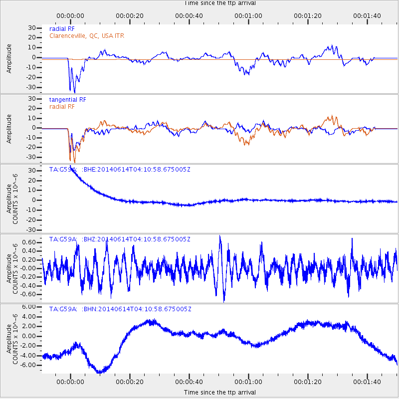
G59A Clarenceville, QC, USA - Earthquake Result Viewer
*The percent match for this event was below the threshold and hence no stack was calculated.
| Earthquake location: |
Hindu Kush Region, Afghanistan |
| Earthquake latitude/longitude: |
36.5/70.7 |
| Earthquake time(UTC): |
2014/06/14 (165) 03:58:41 GMT |
| Earthquake Depth: |
200 km |
| Earthquake Magnitude: |
5.6 MWW, 5.6 MWB, 5.6 MWC |
| Earthquake Catalog/Contributor: |
NEIC PDE/NEIC COMCAT |
|
| Network: |
TA USArray Transportable Network (new EarthScope stations) |
| Station: |
G59A Clarenceville, QC, USA |
| Lat/Lon: |
45.08 N/73.18 W |
| Elevation: |
36 m |
|
| Distance: |
92.5 deg |
| Az: |
335.302 deg |
| Baz: |
28.391 deg |
| Ray Param: |
$rayparam |
*The percent match for this event was below the threshold and hence was not used in the summary stack. |
|
| Radial Match: |
62.33147 % |
| Radial Bump: |
400 |
| Transverse Match: |
43.696907 % |
| Transverse Bump: |
400 |
| SOD ConfigId: |
751272 |
| Insert Time: |
2014-07-17 02:39:45.310 +0000 |
| GWidth: |
2.5 |
| Max Bumps: |
400 |
| Tol: |
0.001 |
|
Signal To Noise
| Channel | StoN | STA | LTA |
| TA:G59A: :BHZ:20140614T04:10:58.675005Z | 1.3240184 | 3.039632E-7 | 2.2957627E-7 |
| TA:G59A: :BHN:20140614T04:10:58.675005Z | 0.73286843 | 1.2020533E-5 | 1.6402035E-5 |
| TA:G59A: :BHE:20140614T04:10:58.675005Z | 1.0639565 | 1.0762333E-5 | 1.0115387E-5 |
| Arrivals |
| Ps | |
| PpPs | |
| PsPs/PpSs | |


