You are here: Home > Network List > MB - Montana Regional Seismic Network Stations List
> Station JTMT Jette Lake, Montana > Earthquake Result Viewer
JTMT Jette Lake, Montana - Earthquake Result Viewer
| Earthquake location: |
Komandorskiye Ostrova Region |
| Earthquake latitude/longitude: |
55.3/166.9 |
| Earthquake time(UTC): |
2014/07/03 (184) 02:56:41 GMT |
| Earthquake Depth: |
23 km |
| Earthquake Magnitude: |
5.8 MWP |
| Earthquake Catalog/Contributor: |
NEIC PDE/NEIC COMCAT |
|
| Network: |
MB Montana Regional Seismic Network |
| Station: |
JTMT Jette Lake, Montana |
| Lat/Lon: |
47.75 N/114.28 W |
| Elevation: |
1469 m |
|
| Distance: |
47.2 deg |
| Az: |
64.562 deg |
| Baz: |
310.072 deg |
| Ray Param: |
0.07014138 |
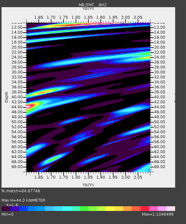
| Estimated Moho Depth: |
44.0 km |
| Estimated Crust Vp/Vs: |
1.60 |
| Assumed Crust Vp: |
6.622 km/s |
| Estimated Crust Vs: |
4.139 km/s |
| Estimated Crust Poisson's Ratio: |
0.18 |
|
| Radial Match: |
84.67746 % |
| Radial Bump: |
400 |
| Transverse Match: |
79.62848 % |
| Transverse Bump: |
400 |
| SOD ConfigId: |
751272 |
| Insert Time: |
2014-07-17 03:27:41.942 +0000 |
| GWidth: |
2.5 |
| Max Bumps: |
400 |
| Tol: |
0.001 |
|

Signal To Noise
| Channel | StoN | STA | LTA |
| MB:JTMT: :BHZ:20140703T03:04:41.040Z | 11.688678 | 9.79753E-7 | 8.3820694E-8 |
| MB:JTMT: :BHN:20140703T03:04:41.040Z | 7.460244 | 4.6377966E-7 | 6.216682E-8 |
| MB:JTMT: :BHE:20140703T03:04:41.040Z | 5.6558933 | 4.1067005E-7 | 7.260923E-8 |
| Arrivals |
| Ps | 4.3 SECOND |
| PpPs | 16 SECOND |
| PsPs/PpSs | 20 SECOND |


