You are here: Home > Network List > CI - Caltech Regional Seismic Network Stations List
> Station MPM Manuel Prospect Mine, California, USA > Earthquake Result Viewer
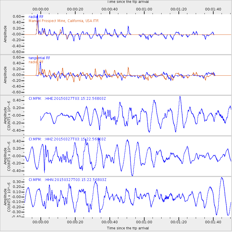
MPM Manuel Prospect Mine, California, USA - Earthquake Result Viewer
*The percent match for this event was below the threshold and hence no stack was calculated.
| Earthquake location: |
Off East Coast Of Honshu, Japan |
| Earthquake latitude/longitude: |
36.3/143.1 |
| Earthquake time(UTC): |
2015/03/27 (086) 03:04:05 GMT |
| Earthquake Depth: |
0.2 km |
| Earthquake Magnitude: |
5.5 MWP |
| Earthquake Catalog/Contributor: |
NEIC PDE/NEIC COMCAT |
|
| Network: |
CI Caltech Regional Seismic Network |
| Station: |
MPM Manuel Prospect Mine, California, USA |
| Lat/Lon: |
36.06 N/117.49 W |
| Elevation: |
185 m |
|
| Distance: |
76.2 deg |
| Az: |
55.412 deg |
| Baz: |
304.855 deg |
| Ray Param: |
$rayparam |
*The percent match for this event was below the threshold and hence was not used in the summary stack. |
|
| Radial Match: |
67.67069 % |
| Radial Bump: |
400 |
| Transverse Match: |
62.54781 % |
| Transverse Bump: |
400 |
| SOD ConfigId: |
7422571 |
| Insert Time: |
2019-04-17 22:10:57.926 +0000 |
| GWidth: |
2.5 |
| Max Bumps: |
400 |
| Tol: |
0.001 |
|
Signal To Noise
| Channel | StoN | STA | LTA |
| CI:MPM: :HHZ:20150327T03:15:22.56803Z | 2.3305125 | 2.0555204E-7 | 8.8200366E-8 |
| CI:MPM: :HHN:20150327T03:15:22.56803Z | 0.9331885 | 1.2812345E-7 | 1.3729642E-7 |
| CI:MPM: :HHE:20150327T03:15:22.56803Z | 1.9109479 | 1.6422885E-7 | 8.594104E-8 |
| Arrivals |
| Ps | |
| PpPs | |
| PsPs/PpSs | |


