You are here: Home > Network List > CN - Canadian National Seismograph Network Stations List
> Station INK INUVIK, NT > Earthquake Result Viewer
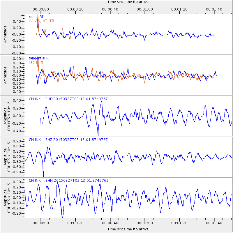
INK INUVIK, NT - Earthquake Result Viewer
*The percent match for this event was below the threshold and hence no stack was calculated.
| Earthquake location: |
Off East Coast Of Honshu, Japan |
| Earthquake latitude/longitude: |
36.3/143.1 |
| Earthquake time(UTC): |
2015/03/27 (086) 03:04:05 GMT |
| Earthquake Depth: |
0.2 km |
| Earthquake Magnitude: |
5.5 MWP |
| Earthquake Catalog/Contributor: |
NEIC PDE/NEIC COMCAT |
|
| Network: |
CN Canadian National Seismograph Network |
| Station: |
INK INUVIK, NT |
| Lat/Lon: |
68.31 N/133.53 W |
| Elevation: |
44 m |
|
| Distance: |
54.4 deg |
| Az: |
27.012 deg |
| Baz: |
279.371 deg |
| Ray Param: |
$rayparam |
*The percent match for this event was below the threshold and hence was not used in the summary stack. |
|
| Radial Match: |
64.43348 % |
| Radial Bump: |
400 |
| Transverse Match: |
70.187485 % |
| Transverse Bump: |
400 |
| SOD ConfigId: |
7422571 |
| Insert Time: |
2019-04-17 22:11:22.822 +0000 |
| GWidth: |
2.5 |
| Max Bumps: |
400 |
| Tol: |
0.001 |
|
Signal To Noise
| Channel | StoN | STA | LTA |
| CN:INK: :BHZ:20150327T03:13:01.874976Z | 2.540943 | 3.8110048E-7 | 1.4998389E-7 |
| CN:INK: :BHN:20150327T03:13:01.874976Z | 1.2730669 | 1.6909154E-7 | 1.328222E-7 |
| CN:INK: :BHE:20150327T03:13:01.874976Z | 2.6752326 | 2.3808195E-7 | 8.899486E-8 |
| Arrivals |
| Ps | |
| PpPs | |
| PsPs/PpSs | |


