You are here: Home > Network List > II - Global Seismograph Network (GSN - IRIS/IDA) Stations List
> Station WRAB Tennant Creek, NT, Australia > Earthquake Result Viewer
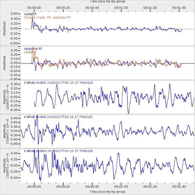
WRAB Tennant Creek, NT, Australia - Earthquake Result Viewer
*The percent match for this event was below the threshold and hence no stack was calculated.
| Earthquake location: |
Off East Coast Of Honshu, Japan |
| Earthquake latitude/longitude: |
36.3/143.1 |
| Earthquake time(UTC): |
2015/03/27 (086) 03:04:05 GMT |
| Earthquake Depth: |
0.2 km |
| Earthquake Magnitude: |
5.5 MWP |
| Earthquake Catalog/Contributor: |
NEIC PDE/NEIC COMCAT |
|
| Network: |
II Global Seismograph Network (GSN - IRIS/IDA) |
| Station: |
WRAB Tennant Creek, NT, Australia |
| Lat/Lon: |
19.93 S/134.36 E |
| Elevation: |
366 m |
|
| Distance: |
56.6 deg |
| Az: |
189.892 deg |
| Baz: |
8.481 deg |
| Ray Param: |
$rayparam |
*The percent match for this event was below the threshold and hence was not used in the summary stack. |
|
| Radial Match: |
69.248825 % |
| Radial Bump: |
400 |
| Transverse Match: |
61.027462 % |
| Transverse Bump: |
400 |
| SOD ConfigId: |
7422571 |
| Insert Time: |
2019-04-17 22:12:24.267 +0000 |
| GWidth: |
2.5 |
| Max Bumps: |
400 |
| Tol: |
0.001 |
|
Signal To Noise
| Channel | StoN | STA | LTA |
| II:WRAB:00:BHZ:20150327T03:13:17.769019Z | 2.8267708 | 5.8780444E-7 | 2.0794202E-7 |
| II:WRAB:00:BH1:20150327T03:13:17.769019Z | 2.5794692 | 2.9833325E-7 | 1.1565684E-7 |
| II:WRAB:00:BH2:20150327T03:13:17.769019Z | 0.78450006 | 9.639676E-8 | 1.2287667E-7 |
| Arrivals |
| Ps | |
| PpPs | |
| PsPs/PpSs | |


