You are here: Home > Network List > TA - USArray Transportable Network (new EarthScope stations) Stations List
> Station J01E Myrtle Point, OR, USA > Earthquake Result Viewer
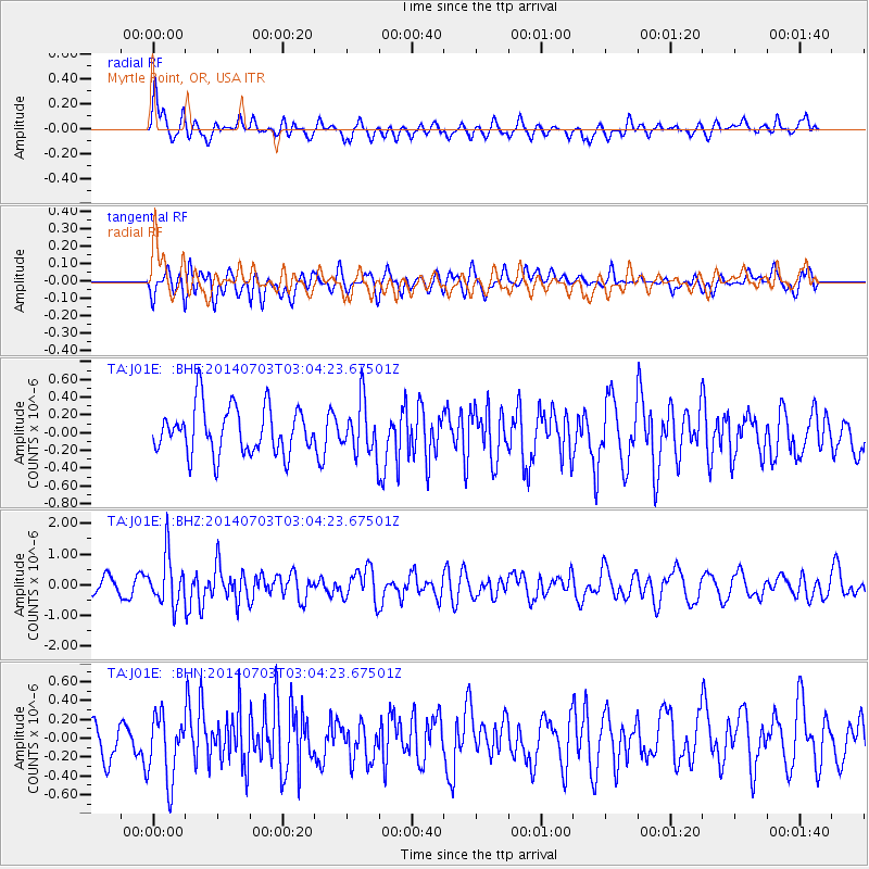
J01E Myrtle Point, OR, USA - Earthquake Result Viewer
*The percent match for this event was below the threshold and hence no stack was calculated.
| Earthquake location: |
Komandorskiye Ostrova Region |
| Earthquake latitude/longitude: |
55.3/166.9 |
| Earthquake time(UTC): |
2014/07/03 (184) 02:56:41 GMT |
| Earthquake Depth: |
23 km |
| Earthquake Magnitude: |
5.8 MWP |
| Earthquake Catalog/Contributor: |
NEIC PDE/NEIC COMCAT |
|
| Network: |
TA USArray Transportable Network (new EarthScope stations) |
| Station: |
J01E Myrtle Point, OR, USA |
| Lat/Lon: |
43.16 N/123.93 W |
| Elevation: |
128 m |
|
| Distance: |
44.9 deg |
| Az: |
75.519 deg |
| Baz: |
310.822 deg |
| Ray Param: |
$rayparam |
*The percent match for this event was below the threshold and hence was not used in the summary stack. |
|
| Radial Match: |
46.953995 % |
| Radial Bump: |
396 |
| Transverse Match: |
56.220276 % |
| Transverse Bump: |
400 |
| SOD ConfigId: |
751272 |
| Insert Time: |
2014-07-17 03:42:46.113 +0000 |
| GWidth: |
2.5 |
| Max Bumps: |
400 |
| Tol: |
0.001 |
|
Signal To Noise
| Channel | StoN | STA | LTA |
| TA:J01E: :BHZ:20140703T03:04:23.67501Z | 2.8930597 | 8.0591593E-7 | 2.785687E-7 |
| TA:J01E: :BHN:20140703T03:04:23.67501Z | 1.2330098 | 3.5886643E-7 | 2.910491E-7 |
| TA:J01E: :BHE:20140703T03:04:23.67501Z | 1.1241515 | 2.947804E-7 | 2.622248E-7 |
| Arrivals |
| Ps | |
| PpPs | |
| PsPs/PpSs | |


