You are here: Home > Network List > TA - USArray Transportable Network (new EarthScope stations) Stations List
> Station P51A Williamsport, OH, USA > Earthquake Result Viewer
P51A Williamsport, OH, USA - Earthquake Result Viewer

| Earthquake location: |
Komandorskiye Ostrova Region |
| Earthquake latitude/longitude: |
55.3/166.9 |
| Earthquake time(UTC): |
2014/07/03 (184) 02:56:41 GMT |
| Earthquake Depth: |
23 km |
| Earthquake Magnitude: |
5.8 MWP |
| Earthquake Catalog/Contributor: |
NEIC PDE/NEIC COMCAT |
|
| Network: |
TA USArray Transportable Network (new EarthScope stations) |
| Station: |
P51A Williamsport, OH, USA |
| Lat/Lon: |
39.48 N/83.06 W |
| Elevation: |
211 m |
|
| Distance: |
68.4 deg |
| Az: |
51.411 deg |
| Baz: |
324.718 deg |
| Ray Param: |
0.0562811 |
| Estimated Moho Depth: |
42.25 km |
| Estimated Crust Vp/Vs: |
1.70 |
| Assumed Crust Vp: |
6.232 km/s |
| Estimated Crust Vs: |
3.666 km/s |
| Estimated Crust Poisson's Ratio: |
0.24 |
|
| Radial Match: |
85.63244 % |
| Radial Bump: |
400 |
| Transverse Match: |
64.42703 % |
| Transverse Bump: |
400 |
| SOD ConfigId: |
751272 |
| Insert Time: |
2014-07-17 03:45:25.010 +0000 |
| GWidth: |
2.5 |
| Max Bumps: |
400 |
| Tol: |
0.001 |
|
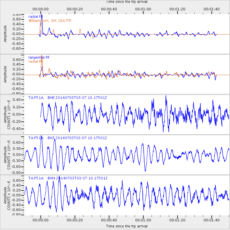
Signal To Noise
| Channel | StoN | STA | LTA |
| TA:P51A: :BHZ:20140703T03:07:10.17501Z | 2.3977969 | 5.0067644E-7 | 2.0880685E-7 |
| TA:P51A: :BHN:20140703T03:07:10.17501Z | 1.7179118 | 3.334383E-7 | 1.9409511E-7 |
| TA:P51A: :BHE:20140703T03:07:10.17501Z | 0.6885755 | 1.3483499E-7 | 1.958173E-7 |
| Arrivals |
| Ps | 4.9 SECOND |
| PpPs | 18 SECOND |
| PsPs/PpSs | 23 SECOND |


