You are here: Home > Network List > TA - USArray Transportable Network (new EarthScope stations) Stations List
> Station T54A Tazewell, VA, USA > Earthquake Result Viewer
T54A Tazewell, VA, USA - Earthquake Result Viewer
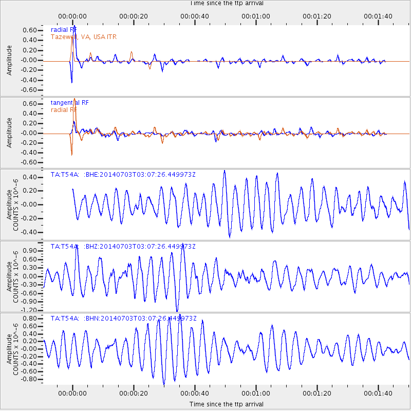
| Earthquake location: |
Komandorskiye Ostrova Region |
| Earthquake latitude/longitude: |
55.3/166.9 |
| Earthquake time(UTC): |
2014/07/03 (184) 02:56:41 GMT |
| Earthquake Depth: |
23 km |
| Earthquake Magnitude: |
5.8 MWP |
| Earthquake Catalog/Contributor: |
NEIC PDE/NEIC COMCAT |
|
| Network: |
TA USArray Transportable Network (new EarthScope stations) |
| Station: |
T54A Tazewell, VA, USA |
| Lat/Lon: |
37.06 N/81.58 W |
| Elevation: |
852 m |
|
| Distance: |
71.1 deg |
| Az: |
51.856 deg |
| Baz: |
325.788 deg |
| Ray Param: |
0.05452873 |
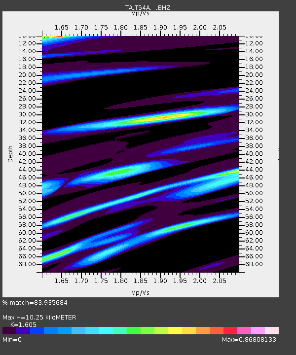
| Estimated Moho Depth: |
10.25 km |
| Estimated Crust Vp/Vs: |
1.61 |
| Assumed Crust Vp: |
6.159 km/s |
| Estimated Crust Vs: |
3.837 km/s |
| Estimated Crust Poisson's Ratio: |
0.18 |
|
| Radial Match: |
83.935684 % |
| Radial Bump: |
400 |
| Transverse Match: |
57.85721 % |
| Transverse Bump: |
400 |
| SOD ConfigId: |
751272 |
| Insert Time: |
2014-07-17 03:46:29.233 +0000 |
| GWidth: |
2.5 |
| Max Bumps: |
400 |
| Tol: |
0.001 |
|
Signal To Noise
| Channel | StoN | STA | LTA |
| TA:T54A: :BHZ:20140703T03:07:26.449973Z | 2.6538403 | 5.6397346E-7 | 2.1251222E-7 |
| TA:T54A: :BHN:20140703T03:07:26.449973Z | 1.7709743 | 3.2697758E-7 | 1.8463146E-7 |
| TA:T54A: :BHE:20140703T03:07:26.449973Z | 1.5384387 | 1.9512973E-7 | 1.2683621E-7 |
| Arrivals |
| Ps | 1.0 SECOND |
| PpPs | 4.2 SECOND |
| PsPs/PpSs | 5.2 SECOND |


