You are here: Home > Network List > UW - Pacific Northwest Regional Seismic Network Stations List
> Station UMAT Pilot Rock, OR, USA > Earthquake Result Viewer
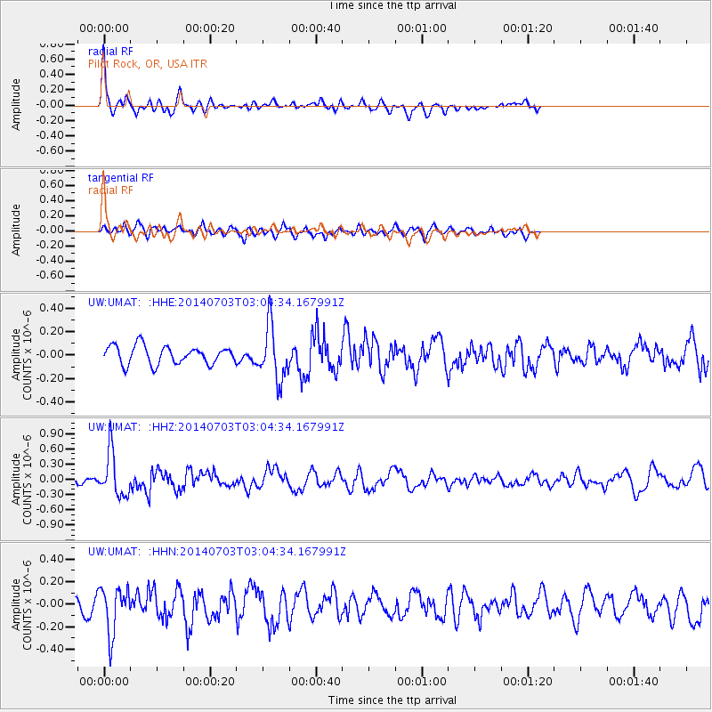
UMAT Pilot Rock, OR, USA - Earthquake Result Viewer
*The percent match for this event was below the threshold and hence no stack was calculated.
| Earthquake location: |
Komandorskiye Ostrova Region |
| Earthquake latitude/longitude: |
55.3/166.9 |
| Earthquake time(UTC): |
2014/07/03 (184) 02:56:41 GMT |
| Earthquake Depth: |
23 km |
| Earthquake Magnitude: |
5.8 MWP |
| Earthquake Catalog/Contributor: |
NEIC PDE/NEIC COMCAT |
|
| Network: |
UW Pacific Northwest Regional Seismic Network |
| Station: |
UMAT Pilot Rock, OR, USA |
| Lat/Lon: |
45.29 N/118.96 W |
| Elevation: |
1318 m |
|
| Distance: |
46.3 deg |
| Az: |
70.003 deg |
| Baz: |
310.419 deg |
| Ray Param: |
$rayparam |
*The percent match for this event was below the threshold and hence was not used in the summary stack. |
|
| Radial Match: |
78.295494 % |
| Radial Bump: |
334 |
| Transverse Match: |
65.859 % |
| Transverse Bump: |
400 |
| SOD ConfigId: |
751272 |
| Insert Time: |
2014-07-17 03:55:13.029 +0000 |
| GWidth: |
2.5 |
| Max Bumps: |
400 |
| Tol: |
0.001 |
|
Signal To Noise
| Channel | StoN | STA | LTA |
| UW:UMAT: :HHZ:20140703T03:04:34.167991Z | 5.841129 | 4.4229301E-7 | 7.572047E-8 |
| UW:UMAT: :HHN:20140703T03:04:34.167991Z | 4.1757245 | 2.0856271E-7 | 4.9946472E-8 |
| UW:UMAT: :HHE:20140703T03:04:34.167991Z | 3.003176 | 2.3216533E-7 | 7.73066E-8 |
| Arrivals |
| Ps | |
| PpPs | |
| PsPs/PpSs | |


