You are here: Home > Network List > TA - USArray Transportable Network (new EarthScope stations) Stations List
> Station M51A Elyria, OH, USA > Earthquake Result Viewer
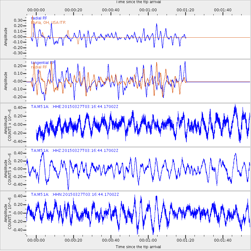
M51A Elyria, OH, USA - Earthquake Result Viewer
*The percent match for this event was below the threshold and hence no stack was calculated.
| Earthquake location: |
Off East Coast Of Honshu, Japan |
| Earthquake latitude/longitude: |
36.3/143.1 |
| Earthquake time(UTC): |
2015/03/27 (086) 03:04:05 GMT |
| Earthquake Depth: |
0.2 km |
| Earthquake Magnitude: |
5.5 MWP |
| Earthquake Catalog/Contributor: |
NEIC PDE/NEIC COMCAT |
|
| Network: |
TA USArray Transportable Network (new EarthScope stations) |
| Station: |
M51A Elyria, OH, USA |
| Lat/Lon: |
41.33 N/82.18 W |
| Elevation: |
239 m |
|
| Distance: |
92.3 deg |
| Az: |
32.397 deg |
| Baz: |
324.927 deg |
| Ray Param: |
$rayparam |
*The percent match for this event was below the threshold and hence was not used in the summary stack. |
|
| Radial Match: |
53.72573 % |
| Radial Bump: |
382 |
| Transverse Match: |
47.56769 % |
| Transverse Bump: |
400 |
| SOD ConfigId: |
7422571 |
| Insert Time: |
2019-04-17 22:15:59.225 +0000 |
| GWidth: |
2.5 |
| Max Bumps: |
400 |
| Tol: |
0.001 |
|
Signal To Noise
| Channel | StoN | STA | LTA |
| TA:M51A: :HHZ:20150327T03:16:44.17002Z | 1.2814415 | 2.3787285E-7 | 1.8562912E-7 |
| TA:M51A: :HHN:20150327T03:16:44.17002Z | 1.3232819 | 1.7494138E-7 | 1.3220266E-7 |
| TA:M51A: :HHE:20150327T03:16:44.17002Z | 1.1330777 | 1.404939E-7 | 1.2399316E-7 |
| Arrivals |
| Ps | |
| PpPs | |
| PsPs/PpSs | |


