You are here: Home > Network List > TA - USArray Transportable Network (new EarthScope stations) Stations List
> Station T25A Trinidad, CO, USA > Earthquake Result Viewer
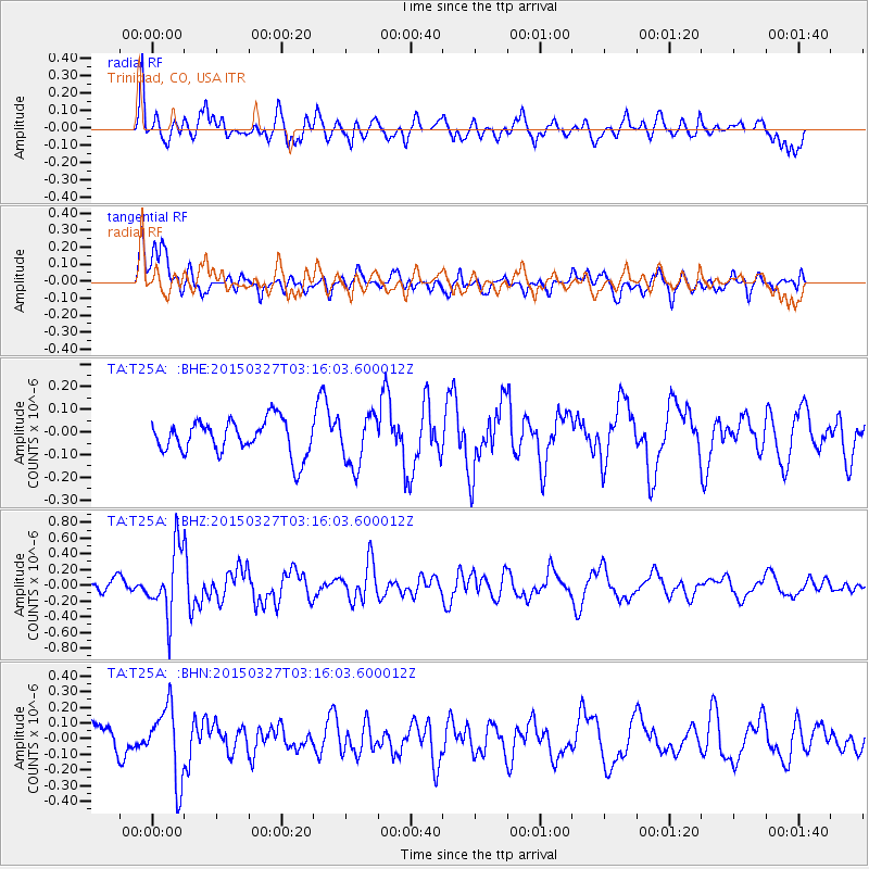
T25A Trinidad, CO, USA - Earthquake Result Viewer
*The percent match for this event was below the threshold and hence no stack was calculated.
| Earthquake location: |
Off East Coast Of Honshu, Japan |
| Earthquake latitude/longitude: |
36.3/143.1 |
| Earthquake time(UTC): |
2015/03/27 (086) 03:04:05 GMT |
| Earthquake Depth: |
0.2 km |
| Earthquake Magnitude: |
5.5 MWP |
| Earthquake Catalog/Contributor: |
NEIC PDE/NEIC COMCAT |
|
| Network: |
TA USArray Transportable Network (new EarthScope stations) |
| Station: |
T25A Trinidad, CO, USA |
| Lat/Lon: |
37.14 N/104.41 W |
| Elevation: |
2017 m |
|
| Distance: |
83.8 deg |
| Az: |
47.971 deg |
| Baz: |
311.344 deg |
| Ray Param: |
$rayparam |
*The percent match for this event was below the threshold and hence was not used in the summary stack. |
|
| Radial Match: |
73.2637 % |
| Radial Bump: |
400 |
| Transverse Match: |
60.159416 % |
| Transverse Bump: |
400 |
| SOD ConfigId: |
7422571 |
| Insert Time: |
2019-04-17 22:16:18.811 +0000 |
| GWidth: |
2.5 |
| Max Bumps: |
400 |
| Tol: |
0.001 |
|
Signal To Noise
| Channel | StoN | STA | LTA |
| TA:T25A: :BHZ:20150327T03:16:03.600012Z | 4.858927 | 4.2250588E-7 | 8.6954564E-8 |
| TA:T25A: :BHN:20150327T03:16:03.600012Z | 2.122788 | 2.3197562E-7 | 1.0927875E-7 |
| TA:T25A: :BHE:20150327T03:16:03.600012Z | 1.6381474 | 1.4566261E-7 | 8.8919116E-8 |
| Arrivals |
| Ps | |
| PpPs | |
| PsPs/PpSs | |


