You are here: Home > Network List > TA - USArray Transportable Network (new EarthScope stations) Stations List
> Station J04D Umpqua National Forest, Toketee, OR, USA > Earthquake Result Viewer
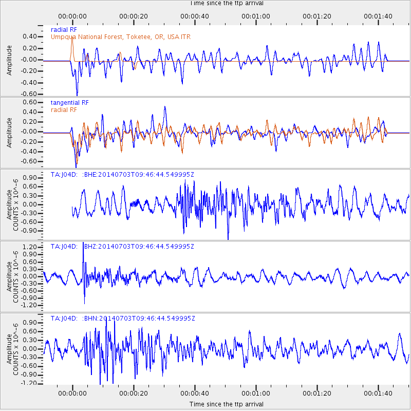
J04D Umpqua National Forest, Toketee, OR, USA - Earthquake Result Viewer
*The percent match for this event was below the threshold and hence no stack was calculated.
| Earthquake location: |
South Of Fiji Islands |
| Earthquake latitude/longitude: |
-22.1/-179.4 |
| Earthquake time(UTC): |
2014/07/03 (184) 09:35:49 GMT |
| Earthquake Depth: |
599 km |
| Earthquake Magnitude: |
5.6 MB |
| Earthquake Catalog/Contributor: |
NEIC PDE/NEIC COMCAT |
|
| Network: |
TA USArray Transportable Network (new EarthScope stations) |
| Station: |
J04D Umpqua National Forest, Toketee, OR, USA |
| Lat/Lon: |
43.24 N/122.11 W |
| Elevation: |
1948 m |
|
| Distance: |
83.6 deg |
| Az: |
38.246 deg |
| Baz: |
231.795 deg |
| Ray Param: |
$rayparam |
*The percent match for this event was below the threshold and hence was not used in the summary stack. |
|
| Radial Match: |
51.085594 % |
| Radial Bump: |
400 |
| Transverse Match: |
60.961243 % |
| Transverse Bump: |
400 |
| SOD ConfigId: |
751272 |
| Insert Time: |
2014-07-17 10:08:27.924 +0000 |
| GWidth: |
2.5 |
| Max Bumps: |
400 |
| Tol: |
0.001 |
|
Signal To Noise
| Channel | StoN | STA | LTA |
| TA:J04D: :BHZ:20140703T09:46:44.549995Z | 2.6615708 | 4.2138583E-7 | 1.5832224E-7 |
| TA:J04D: :BHN:20140703T09:46:44.549995Z | 1.0228871 | 2.2577674E-7 | 2.2072498E-7 |
| TA:J04D: :BHE:20140703T09:46:44.549995Z | 0.68873507 | 1.8302072E-7 | 2.6573457E-7 |
| Arrivals |
| Ps | |
| PpPs | |
| PsPs/PpSs | |


