You are here: Home > Network List > UW - Pacific Northwest Regional Seismic Network Stations List
> Station UMAT Pilot Rock, OR, USA > Earthquake Result Viewer
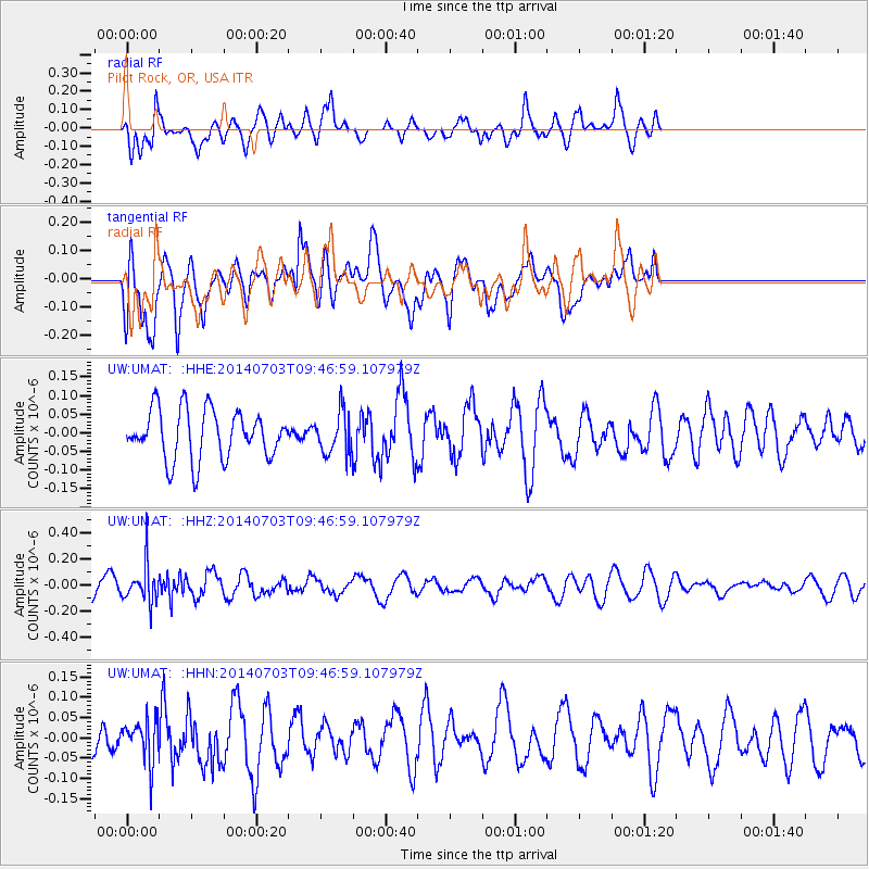
UMAT Pilot Rock, OR, USA - Earthquake Result Viewer
*The percent match for this event was below the threshold and hence no stack was calculated.
| Earthquake location: |
South Of Fiji Islands |
| Earthquake latitude/longitude: |
-22.1/-179.4 |
| Earthquake time(UTC): |
2014/07/03 (184) 09:35:49 GMT |
| Earthquake Depth: |
599 km |
| Earthquake Magnitude: |
5.6 MB |
| Earthquake Catalog/Contributor: |
NEIC PDE/NEIC COMCAT |
|
| Network: |
UW Pacific Northwest Regional Seismic Network |
| Station: |
UMAT Pilot Rock, OR, USA |
| Lat/Lon: |
45.29 N/118.96 W |
| Elevation: |
1318 m |
|
| Distance: |
86.7 deg |
| Az: |
37.977 deg |
| Baz: |
233.964 deg |
| Ray Param: |
$rayparam |
*The percent match for this event was below the threshold and hence was not used in the summary stack. |
|
| Radial Match: |
58.307858 % |
| Radial Bump: |
400 |
| Transverse Match: |
54.69737 % |
| Transverse Bump: |
400 |
| SOD ConfigId: |
751272 |
| Insert Time: |
2014-07-17 10:11:01.310 +0000 |
| GWidth: |
2.5 |
| Max Bumps: |
400 |
| Tol: |
0.001 |
|
Signal To Noise
| Channel | StoN | STA | LTA |
| UW:UMAT: :HHZ:20140703T09:46:59.107979Z | 1.9722164 | 1.404027E-7 | 7.1190314E-8 |
| UW:UMAT: :HHN:20140703T09:46:59.107979Z | 1.110465 | 5.2386632E-8 | 4.7175398E-8 |
| UW:UMAT: :HHE:20140703T09:46:59.107979Z | 0.8536515 | 5.5791535E-8 | 6.535634E-8 |
| Arrivals |
| Ps | |
| PpPs | |
| PsPs/PpSs | |


