You are here: Home > Network List > GS - US Geological Survey Networks Stations List
> Station ID03 East of Rte 461 near Challis, ID, USA > Earthquake Result Viewer
ID03 East of Rte 461 near Challis, ID, USA - Earthquake Result Viewer
| Earthquake location: |
Komandorskiye Ostrova Region |
| Earthquake latitude/longitude: |
55.2/166.9 |
| Earthquake time(UTC): |
2014/07/03 (184) 12:05:22 GMT |
| Earthquake Depth: |
10 km |
| Earthquake Magnitude: |
5.9 MWP |
| Earthquake Catalog/Contributor: |
NEIC PDE/NEIC COMCAT |
|
| Network: |
GS US Geological Survey Networks |
| Station: |
ID03 East of Rte 461 near Challis, ID, USA |
| Lat/Lon: |
44.45 N/113.88 W |
| Elevation: |
1878 m |
|
| Distance: |
49.5 deg |
| Az: |
67.589 deg |
| Baz: |
312.274 deg |
| Ray Param: |
0.0686301 |
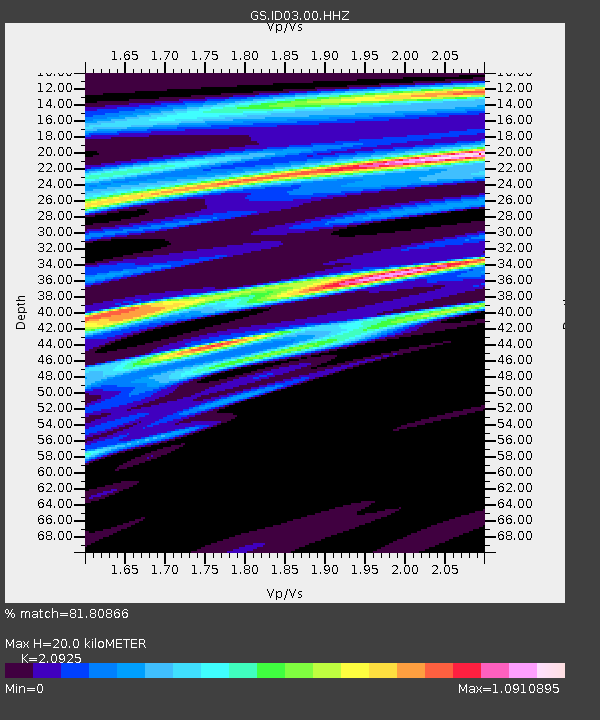
| Estimated Moho Depth: |
20.0 km |
| Estimated Crust Vp/Vs: |
2.09 |
| Assumed Crust Vp: |
6.577 km/s |
| Estimated Crust Vs: |
3.143 km/s |
| Estimated Crust Poisson's Ratio: |
0.35 |
|
| Radial Match: |
81.80866 % |
| Radial Bump: |
400 |
| Transverse Match: |
42.33445 % |
| Transverse Bump: |
400 |
| SOD ConfigId: |
751272 |
| Insert Time: |
2014-07-17 12:23:53.741 +0000 |
| GWidth: |
2.5 |
| Max Bumps: |
400 |
| Tol: |
0.001 |
|

Signal To Noise
| Channel | StoN | STA | LTA |
| GS:ID03:00:HHZ:20140703T12:13:42.740002Z | 5.4500065 | 5.3400214E-7 | 9.7981925E-8 |
| GS:ID03:00:HH1:20140703T12:13:42.740002Z | 1.125831 | 5.183367E-7 | 4.6040364E-7 |
| GS:ID03:00:HH2:20140703T12:13:42.740002Z | 3.40752 | 6.2517347E-7 | 1.8346877E-7 |
| Arrivals |
| Ps | 3.5 SECOND |
| PpPs | 8.9 SECOND |
| PsPs/PpSs | 12 SECOND |


