You are here: Home > Network List > GS - US Geological Survey Networks Stations List
> Station ID04 Mogan Creek Rd (Rte 129), ID, USA > Earthquake Result Viewer
ID04 Mogan Creek Rd (Rte 129), ID, USA - Earthquake Result Viewer
| Earthquake location: |
Komandorskiye Ostrova Region |
| Earthquake latitude/longitude: |
55.2/166.9 |
| Earthquake time(UTC): |
2014/07/03 (184) 12:05:22 GMT |
| Earthquake Depth: |
10 km |
| Earthquake Magnitude: |
5.9 MWP |
| Earthquake Catalog/Contributor: |
NEIC PDE/NEIC COMCAT |
|
| Network: |
GS US Geological Survey Networks |
| Station: |
ID04 Mogan Creek Rd (Rte 129), ID, USA |
| Lat/Lon: |
44.85 N/114.24 W |
| Elevation: |
2500 m |
|
| Distance: |
49.1 deg |
| Az: |
67.435 deg |
| Baz: |
311.919 deg |
| Ray Param: |
0.06892417 |
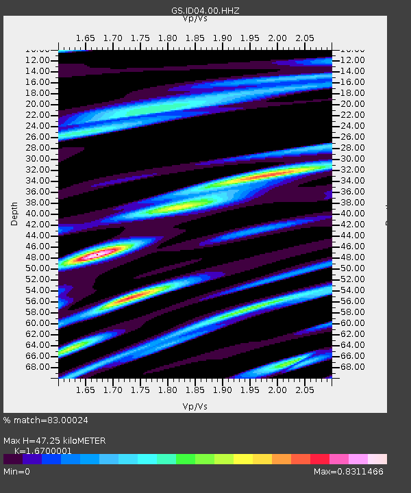
| Estimated Moho Depth: |
47.25 km |
| Estimated Crust Vp/Vs: |
1.67 |
| Assumed Crust Vp: |
6.577 km/s |
| Estimated Crust Vs: |
3.938 km/s |
| Estimated Crust Poisson's Ratio: |
0.22 |
|
| Radial Match: |
83.00024 % |
| Radial Bump: |
400 |
| Transverse Match: |
77.21177 % |
| Transverse Bump: |
400 |
| SOD ConfigId: |
751272 |
| Insert Time: |
2014-07-17 12:23:56.774 +0000 |
| GWidth: |
2.5 |
| Max Bumps: |
400 |
| Tol: |
0.001 |
|

Signal To Noise
| Channel | StoN | STA | LTA |
| GS:ID04:00:HHZ:20140703T12:13:39.263989Z | 8.753114 | 5.97938E-7 | 6.831147E-8 |
| GS:ID04:00:HH1:20140703T12:13:39.263989Z | 2.3976402 | 1.8753016E-7 | 7.821447E-8 |
| GS:ID04:00:HH2:20140703T12:13:39.263989Z | 4.6602464 | 3.076761E-7 | 6.602142E-8 |
| Arrivals |
| Ps | 5.1 SECOND |
| PpPs | 18 SECOND |
| PsPs/PpSs | 23 SECOND |


