You are here: Home > Network List > N4 - Central and EAstern US Network Stations List
> Station Q44B Vandalia, IL, USA > Earthquake Result Viewer
Q44B Vandalia, IL, USA - Earthquake Result Viewer
| Earthquake location: |
Komandorskiye Ostrova Region |
| Earthquake latitude/longitude: |
55.2/166.9 |
| Earthquake time(UTC): |
2014/07/03 (184) 12:05:22 GMT |
| Earthquake Depth: |
10 km |
| Earthquake Magnitude: |
5.9 MWP |
| Earthquake Catalog/Contributor: |
NEIC PDE/NEIC COMCAT |
|
| Network: |
N4 Central and EAstern US Network |
| Station: |
Q44B Vandalia, IL, USA |
| Lat/Lon: |
38.90 N/89.02 W |
| Elevation: |
168 m |
|
| Distance: |
66.2 deg |
| Az: |
55.826 deg |
| Baz: |
322.57 deg |
| Ray Param: |
0.05778337 |
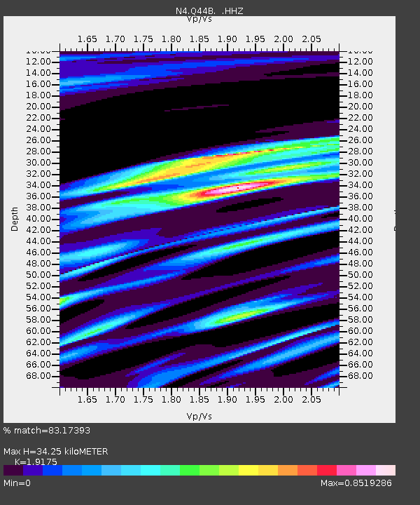
| Estimated Moho Depth: |
34.25 km |
| Estimated Crust Vp/Vs: |
1.92 |
| Assumed Crust Vp: |
6.444 km/s |
| Estimated Crust Vs: |
3.361 km/s |
| Estimated Crust Poisson's Ratio: |
0.31 |
|
| Radial Match: |
83.17393 % |
| Radial Bump: |
383 |
| Transverse Match: |
58.322617 % |
| Transverse Bump: |
400 |
| SOD ConfigId: |
751272 |
| Insert Time: |
2014-07-17 12:35:27.116 +0000 |
| GWidth: |
2.5 |
| Max Bumps: |
400 |
| Tol: |
0.001 |
|

Signal To Noise
| Channel | StoN | STA | LTA |
| N4:Q44B: :HHZ:20140703T12:15:39.32002Z | 2.401083 | 1.213328E-6 | 5.053253E-7 |
| N4:Q44B: :HHN:20140703T12:15:39.32002Z | 1.1665708 | 4.5098386E-7 | 3.8658936E-7 |
| N4:Q44B: :HHE:20140703T12:15:39.32002Z | 0.95974797 | 3.7750473E-7 | 3.9333736E-7 |
| Arrivals |
| Ps | 5.1 SECOND |
| PpPs | 15 SECOND |
| PsPs/PpSs | 20 SECOND |


