You are here: Home > Network List > N4 - Central and EAstern US Network Stations List
> Station U38B Mount Pleasant Farm, Gravette, AR, USA > Earthquake Result Viewer
U38B Mount Pleasant Farm, Gravette, AR, USA - Earthquake Result Viewer
| Earthquake location: |
Komandorskiye Ostrova Region |
| Earthquake latitude/longitude: |
55.2/166.9 |
| Earthquake time(UTC): |
2014/07/03 (184) 12:05:22 GMT |
| Earthquake Depth: |
10 km |
| Earthquake Magnitude: |
5.9 MWP |
| Earthquake Catalog/Contributor: |
NEIC PDE/NEIC COMCAT |
|
| Network: |
N4 Central and EAstern US Network |
| Station: |
U38B Mount Pleasant Farm, Gravette, AR, USA |
| Lat/Lon: |
36.44 N/94.39 W |
| Elevation: |
389 m |
|
| Distance: |
65.5 deg |
| Az: |
61.164 deg |
| Baz: |
321.487 deg |
| Ray Param: |
0.05823212 |
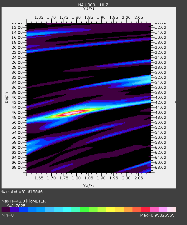
| Estimated Moho Depth: |
46.0 km |
| Estimated Crust Vp/Vs: |
1.78 |
| Assumed Crust Vp: |
6.53 km/s |
| Estimated Crust Vs: |
3.664 km/s |
| Estimated Crust Poisson's Ratio: |
0.27 |
|
| Radial Match: |
81.618866 % |
| Radial Bump: |
348 |
| Transverse Match: |
57.567158 % |
| Transverse Bump: |
317 |
| SOD ConfigId: |
751272 |
| Insert Time: |
2014-07-17 12:35:52.282 +0000 |
| GWidth: |
2.5 |
| Max Bumps: |
400 |
| Tol: |
0.001 |
|

Signal To Noise
| Channel | StoN | STA | LTA |
| N4:U38B: :HHZ:20140703T12:15:34.919995Z | 3.903944 | 5.6507326E-7 | 1.447442E-7 |
| N4:U38B: :HHN:20140703T12:15:34.919995Z | 2.2250957 | 1.9001632E-7 | 8.539693E-8 |
| N4:U38B: :HHE:20140703T12:15:34.919995Z | 2.020627 | 1.8594046E-7 | 9.202117E-8 |
| Arrivals |
| Ps | 5.8 SECOND |
| PpPs | 19 SECOND |
| PsPs/PpSs | 25 SECOND |


