You are here: Home > Network List > N4 - Central and EAstern US Network Stations List
> Station V51A Loudon, TN, USA > Earthquake Result Viewer
V51A Loudon, TN, USA - Earthquake Result Viewer
| Earthquake location: |
Komandorskiye Ostrova Region |
| Earthquake latitude/longitude: |
55.2/166.9 |
| Earthquake time(UTC): |
2014/07/03 (184) 12:05:22 GMT |
| Earthquake Depth: |
10 km |
| Earthquake Magnitude: |
5.9 MWP |
| Earthquake Catalog/Contributor: |
NEIC PDE/NEIC COMCAT |
|
| Network: |
N4 Central and EAstern US Network |
| Station: |
V51A Loudon, TN, USA |
| Lat/Lon: |
35.80 N/84.35 W |
| Elevation: |
243 m |
|
| Distance: |
70.9 deg |
| Az: |
54.569 deg |
| Baz: |
324.931 deg |
| Ray Param: |
0.054692984 |
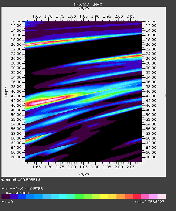
| Estimated Moho Depth: |
44.0 km |
| Estimated Crust Vp/Vs: |
1.69 |
| Assumed Crust Vp: |
6.35 km/s |
| Estimated Crust Vs: |
3.769 km/s |
| Estimated Crust Poisson's Ratio: |
0.23 |
|
| Radial Match: |
93.505516 % |
| Radial Bump: |
239 |
| Transverse Match: |
47.17278 % |
| Transverse Bump: |
377 |
| SOD ConfigId: |
751272 |
| Insert Time: |
2014-07-17 12:35:59.378 +0000 |
| GWidth: |
2.5 |
| Max Bumps: |
400 |
| Tol: |
0.001 |
|

Signal To Noise
| Channel | StoN | STA | LTA |
| N4:V51A: :HHZ:20140703T12:16:08.56001Z | 2.6226115 | 1.3164328E-6 | 5.019549E-7 |
| N4:V51A: :HHN:20140703T12:16:08.56001Z | 2.0891035 | 3.8795787E-7 | 1.8570545E-7 |
| N4:V51A: :HHE:20140703T12:16:08.56001Z | 1.039986 | 5.16467E-7 | 4.9660963E-7 |
| Arrivals |
| Ps | 4.9 SECOND |
| PpPs | 18 SECOND |
| PsPs/PpSs | 23 SECOND |


