You are here: Home > Network List > II - Global Seismograph Network (GSN - IRIS/IDA) Stations List
> Station RAYN Ar Rayn, Saudi Arabia > Earthquake Result Viewer
RAYN Ar Rayn, Saudi Arabia - Earthquake Result Viewer

| Earthquake location: |
Kuril Islands |
| Earthquake latitude/longitude: |
43.0/146.8 |
| Earthquake time(UTC): |
2000/01/28 (028) 14:21:07 GMT |
| Earthquake Depth: |
61 km |
| Earthquake Magnitude: |
6.7 MB, 6.6 MS, 6.8 MW, 6.8 ME |
| Earthquake Catalog/Contributor: |
WHDF/NEIC |
|
| Network: |
II Global Seismograph Network (GSN - IRIS/IDA) |
| Station: |
RAYN Ar Rayn, Saudi Arabia |
| Lat/Lon: |
23.52 N/45.50 E |
| Elevation: |
631 m |
|
| Distance: |
82.1 deg |
| Az: |
294.683 deg |
| Baz: |
46.527 deg |
| Ray Param: |
0.047015343 |
| Estimated Moho Depth: |
38.75 km |
| Estimated Crust Vp/Vs: |
1.78 |
| Assumed Crust Vp: |
6.498 km/s |
| Estimated Crust Vs: |
3.65 km/s |
| Estimated Crust Poisson's Ratio: |
0.27 |
|
| Radial Match: |
98.5777 % |
| Radial Bump: |
338 |
| Transverse Match: |
94.80673 % |
| Transverse Bump: |
400 |
| SOD ConfigId: |
3744 |
| Insert Time: |
2010-03-01 23:44:39.244 +0000 |
| GWidth: |
2.5 |
| Max Bumps: |
400 |
| Tol: |
0.001 |
|
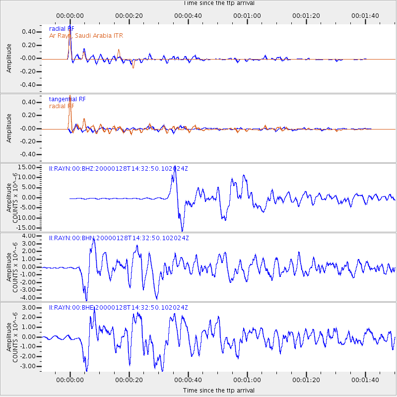
Signal To Noise
| Channel | StoN | STA | LTA |
| II:RAYN:00:BHN:20000128T14:32:50.102024Z | 18.13381 | 9.881206E-7 | 5.4490517E-8 |
| II:RAYN:00:BHE:20000128T14:32:50.102024Z | 5.620223 | 7.5172494E-7 | 1.3375357E-7 |
| II:RAYN:00:BHZ:20000128T14:32:50.102024Z | 24.370188 | 3.5670023E-6 | 1.4636746E-7 |
| Arrivals |
| Ps | 4.8 SECOND |
| PpPs | 16 SECOND |
| PsPs/PpSs | 21 SECOND |


