You are here: Home > Network List > TA - USArray Transportable Network (new EarthScope stations) Stations List
> Station 121A Cookes Peak, Deming, NM, USA > Earthquake Result Viewer
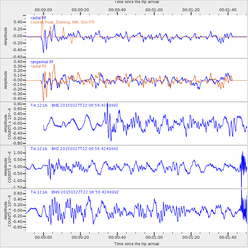
121A Cookes Peak, Deming, NM, USA - Earthquake Result Viewer
*The percent match for this event was below the threshold and hence no stack was calculated.
| Earthquake location: |
Ecuador |
| Earthquake latitude/longitude: |
-1.2/-77.6 |
| Earthquake time(UTC): |
2015/03/27 (086) 21:59:39 GMT |
| Earthquake Depth: |
195 km |
| Earthquake Magnitude: |
5.5 MWW, 5.5 MWB |
| Earthquake Catalog/Contributor: |
NEIC PDE/NEIC COMCAT |
|
| Network: |
TA USArray Transportable Network (new EarthScope stations) |
| Station: |
121A Cookes Peak, Deming, NM, USA |
| Lat/Lon: |
32.53 N/107.79 W |
| Elevation: |
1652 m |
|
| Distance: |
44.0 deg |
| Az: |
322.325 deg |
| Baz: |
133.666 deg |
| Ray Param: |
$rayparam |
*The percent match for this event was below the threshold and hence was not used in the summary stack. |
|
| Radial Match: |
55.08461 % |
| Radial Bump: |
400 |
| Transverse Match: |
53.439243 % |
| Transverse Bump: |
400 |
| SOD ConfigId: |
7422571 |
| Insert Time: |
2019-04-17 22:26:54.359 +0000 |
| GWidth: |
2.5 |
| Max Bumps: |
400 |
| Tol: |
0.001 |
|
Signal To Noise
| Channel | StoN | STA | LTA |
| TA:121A: :BHZ:20150327T22:06:56.424999Z | 2.978805 | 3.02311E-7 | 1.01487345E-7 |
| TA:121A: :BHN:20150327T22:06:56.424999Z | 1.2010645 | 2.206829E-7 | 1.8373943E-7 |
| TA:121A: :BHE:20150327T22:06:56.424999Z | 1.8437443 | 2.8943072E-7 | 1.5697985E-7 |
| Arrivals |
| Ps | |
| PpPs | |
| PsPs/PpSs | |


