You are here: Home > Network List > TA - USArray Transportable Network (new EarthScope stations) Stations List
> Station A04D Lummi Island, WA, USA > Earthquake Result Viewer
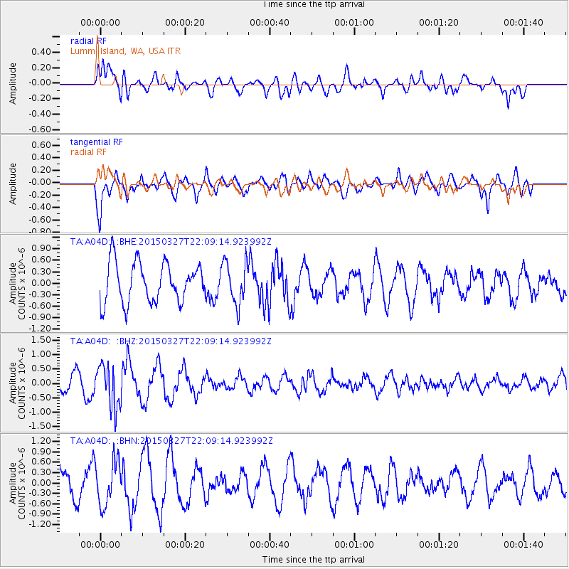
A04D Lummi Island, WA, USA - Earthquake Result Viewer
*The percent match for this event was below the threshold and hence no stack was calculated.
| Earthquake location: |
Ecuador |
| Earthquake latitude/longitude: |
-1.2/-77.6 |
| Earthquake time(UTC): |
2015/03/27 (086) 21:59:39 GMT |
| Earthquake Depth: |
195 km |
| Earthquake Magnitude: |
5.5 MWW, 5.5 MWB |
| Earthquake Catalog/Contributor: |
NEIC PDE/NEIC COMCAT |
|
| Network: |
TA USArray Transportable Network (new EarthScope stations) |
| Station: |
A04D Lummi Island, WA, USA |
| Lat/Lon: |
48.72 N/122.71 W |
| Elevation: |
13 m |
|
| Distance: |
63.2 deg |
| Az: |
328.268 deg |
| Baz: |
127.436 deg |
| Ray Param: |
$rayparam |
*The percent match for this event was below the threshold and hence was not used in the summary stack. |
|
| Radial Match: |
59.840908 % |
| Radial Bump: |
400 |
| Transverse Match: |
72.14752 % |
| Transverse Bump: |
400 |
| SOD ConfigId: |
7422571 |
| Insert Time: |
2019-04-17 22:26:55.576 +0000 |
| GWidth: |
2.5 |
| Max Bumps: |
400 |
| Tol: |
0.001 |
|
Signal To Noise
| Channel | StoN | STA | LTA |
| TA:A04D: :BHZ:20150327T22:09:14.923992Z | 1.6349554 | 7.38459E-7 | 4.5166917E-7 |
| TA:A04D: :BHN:20150327T22:09:14.923992Z | 1.8450638 | 6.3812473E-7 | 3.458551E-7 |
| TA:A04D: :BHE:20150327T22:09:14.923992Z | 1.1006948 | 5.588024E-7 | 5.076816E-7 |
| Arrivals |
| Ps | |
| PpPs | |
| PsPs/PpSs | |


