You are here: Home > Network List > TA - USArray Transportable Network (new EarthScope stations) Stations List
> Station 435B Jarrell, TX, USA > Earthquake Result Viewer
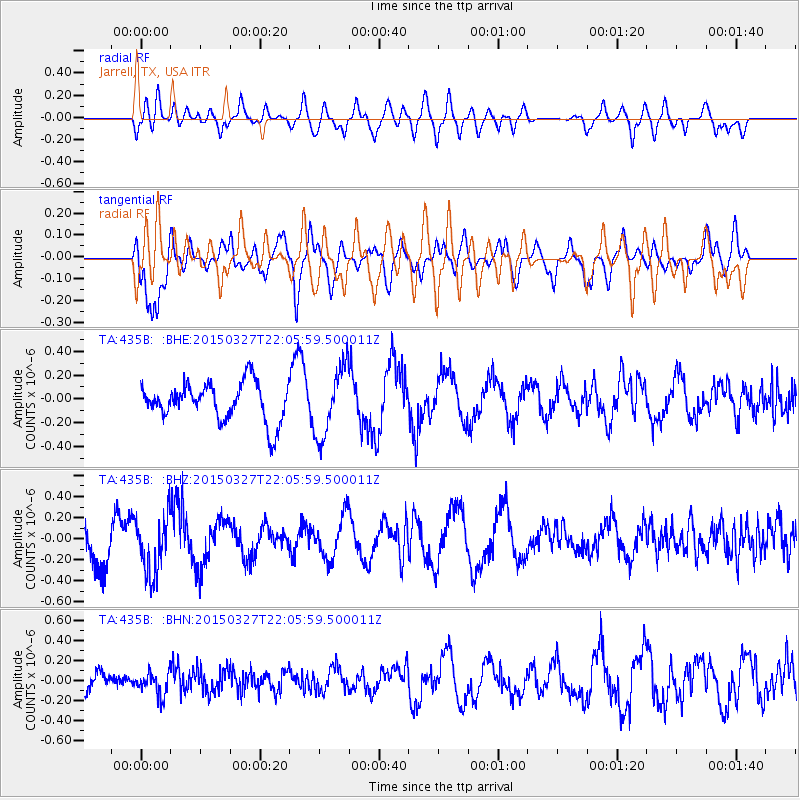
435B Jarrell, TX, USA - Earthquake Result Viewer
*The percent match for this event was below the threshold and hence no stack was calculated.
| Earthquake location: |
Ecuador |
| Earthquake latitude/longitude: |
-1.2/-77.6 |
| Earthquake time(UTC): |
2015/03/27 (086) 21:59:39 GMT |
| Earthquake Depth: |
195 km |
| Earthquake Magnitude: |
5.5 MWW, 5.5 MWB |
| Earthquake Catalog/Contributor: |
NEIC PDE/NEIC COMCAT |
|
| Network: |
TA USArray Transportable Network (new EarthScope stations) |
| Station: |
435B Jarrell, TX, USA |
| Lat/Lon: |
30.78 N/97.58 W |
| Elevation: |
248 m |
|
| Distance: |
37.1 deg |
| Az: |
330.766 deg |
| Baz: |
145.434 deg |
| Ray Param: |
$rayparam |
*The percent match for this event was below the threshold and hence was not used in the summary stack. |
|
| Radial Match: |
61.034874 % |
| Radial Bump: |
400 |
| Transverse Match: |
85.74923 % |
| Transverse Bump: |
400 |
| SOD ConfigId: |
7422571 |
| Insert Time: |
2019-04-17 22:26:55.659 +0000 |
| GWidth: |
2.5 |
| Max Bumps: |
400 |
| Tol: |
0.001 |
|
Signal To Noise
| Channel | StoN | STA | LTA |
| TA:435B: :BHZ:20150327T22:05:59.500011Z | 1.1854784 | 2.703688E-7 | 2.2806724E-7 |
| TA:435B: :BHN:20150327T22:05:59.500011Z | 0.8461908 | 1.1145827E-7 | 1.3171766E-7 |
| TA:435B: :BHE:20150327T22:05:59.500011Z | 1.830969 | 3.01422E-7 | 1.6462431E-7 |
| Arrivals |
| Ps | |
| PpPs | |
| PsPs/PpSs | |


