You are here: Home > Network List > TA - USArray Transportable Network (new EarthScope stations) Stations List
> Station G59A Clarenceville, QC, USA > Earthquake Result Viewer
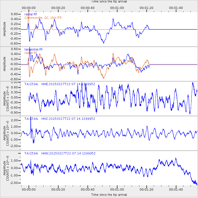
G59A Clarenceville, QC, USA - Earthquake Result Viewer
*The percent match for this event was below the threshold and hence no stack was calculated.
| Earthquake location: |
Ecuador |
| Earthquake latitude/longitude: |
-1.2/-77.6 |
| Earthquake time(UTC): |
2015/03/27 (086) 21:59:39 GMT |
| Earthquake Depth: |
195 km |
| Earthquake Magnitude: |
5.5 MWW, 5.5 MWB |
| Earthquake Catalog/Contributor: |
NEIC PDE/NEIC COMCAT |
|
| Network: |
TA USArray Transportable Network (new EarthScope stations) |
| Station: |
G59A Clarenceville, QC, USA |
| Lat/Lon: |
45.08 N/73.18 W |
| Elevation: |
36 m |
|
| Distance: |
46.2 deg |
| Az: |
4.318 deg |
| Baz: |
186.099 deg |
| Ray Param: |
$rayparam |
*The percent match for this event was below the threshold and hence was not used in the summary stack. |
|
| Radial Match: |
11.953512 % |
| Radial Bump: |
400 |
| Transverse Match: |
32.419918 % |
| Transverse Bump: |
400 |
| SOD ConfigId: |
7422571 |
| Insert Time: |
2019-04-17 22:27:06.782 +0000 |
| GWidth: |
2.5 |
| Max Bumps: |
400 |
| Tol: |
0.001 |
|
Signal To Noise
| Channel | StoN | STA | LTA |
| TA:G59A: :HHZ:20150327T22:07:14.139995Z | 2.1963065 | 7.648997E-7 | 3.4826638E-7 |
| TA:G59A: :HHN:20150327T22:07:14.139995Z | 1.2282978 | 7.4036507E-7 | 6.02757E-7 |
| TA:G59A: :HHE:20150327T22:07:14.139995Z | 1.6982723 | 4.3550668E-7 | 2.56441E-7 |
| Arrivals |
| Ps | |
| PpPs | |
| PsPs/PpSs | |


