You are here: Home > Network List > TA - USArray Transportable Network (new EarthScope stations) Stations List
> Station T57A Hurt, VA, USA > Earthquake Result Viewer
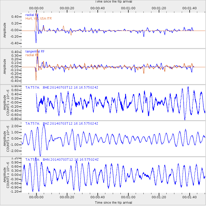
T57A Hurt, VA, USA - Earthquake Result Viewer
*The percent match for this event was below the threshold and hence no stack was calculated.
| Earthquake location: |
Komandorskiye Ostrova Region |
| Earthquake latitude/longitude: |
55.2/166.9 |
| Earthquake time(UTC): |
2014/07/03 (184) 12:05:22 GMT |
| Earthquake Depth: |
10 km |
| Earthquake Magnitude: |
5.9 MWP |
| Earthquake Catalog/Contributor: |
NEIC PDE/NEIC COMCAT |
|
| Network: |
TA USArray Transportable Network (new EarthScope stations) |
| Station: |
T57A Hurt, VA, USA |
| Lat/Lon: |
37.00 N/79.25 W |
| Elevation: |
230 m |
|
| Distance: |
72.2 deg |
| Az: |
50.278 deg |
| Baz: |
326.585 deg |
| Ray Param: |
$rayparam |
*The percent match for this event was below the threshold and hence was not used in the summary stack. |
|
| Radial Match: |
83.576935 % |
| Radial Bump: |
400 |
| Transverse Match: |
70.01907 % |
| Transverse Bump: |
400 |
| SOD ConfigId: |
751272 |
| Insert Time: |
2014-07-17 12:59:25.927 +0000 |
| GWidth: |
2.5 |
| Max Bumps: |
400 |
| Tol: |
0.001 |
|
Signal To Noise
| Channel | StoN | STA | LTA |
| TA:T57A: :BHZ:20140703T12:16:16.575024Z | 3.3439844 | 1.6319519E-6 | 4.880262E-7 |
| TA:T57A: :BHN:20140703T12:16:16.575024Z | 2.014854 | 7.8850695E-7 | 3.9134696E-7 |
| TA:T57A: :BHE:20140703T12:16:16.575024Z | 0.5060537 | 1.3916065E-7 | 2.7499186E-7 |
| Arrivals |
| Ps | |
| PpPs | |
| PsPs/PpSs | |


