You are here: Home > Network List > US - United States National Seismic Network Stations List
> Station TPNV Topopah Spring, Nevada, USA > Earthquake Result Viewer
TPNV Topopah Spring, Nevada, USA - Earthquake Result Viewer
| Earthquake location: |
Komandorskiye Ostrova Region |
| Earthquake latitude/longitude: |
55.2/166.9 |
| Earthquake time(UTC): |
2014/07/03 (184) 12:05:22 GMT |
| Earthquake Depth: |
10 km |
| Earthquake Magnitude: |
5.9 MWP |
| Earthquake Catalog/Contributor: |
NEIC PDE/NEIC COMCAT |
|
| Network: |
US United States National Seismic Network |
| Station: |
TPNV Topopah Spring, Nevada, USA |
| Lat/Lon: |
36.95 N/116.25 W |
| Elevation: |
1600 m |
|
| Distance: |
53.5 deg |
| Az: |
76.066 deg |
| Baz: |
316.015 deg |
| Ray Param: |
0.066069454 |
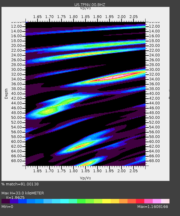
| Estimated Moho Depth: |
33.0 km |
| Estimated Crust Vp/Vs: |
1.96 |
| Assumed Crust Vp: |
6.279 km/s |
| Estimated Crust Vs: |
3.199 km/s |
| Estimated Crust Poisson's Ratio: |
0.32 |
|
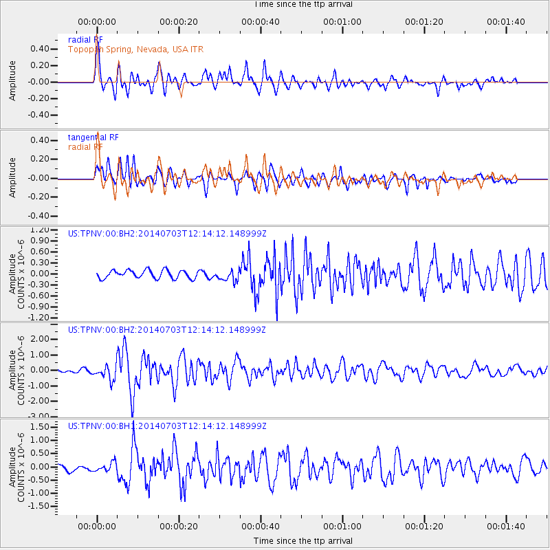
| Radial Match: |
91.00138 % |
| Radial Bump: |
400 |
| Transverse Match: |
81.76157 % |
| Transverse Bump: |
400 |
| SOD ConfigId: |
751272 |
| Insert Time: |
2014-07-17 13:04:50.112 +0000 |
| GWidth: |
2.5 |
| Max Bumps: |
400 |
| Tol: |
0.001 |
|
Signal To Noise
| Channel | StoN | STA | LTA |
| US:TPNV:00:BHZ:20140703T12:14:12.148999Z | 4.498629 | 4.7676176E-7 | 1.0597934E-7 |
| US:TPNV:00:BH1:20140703T12:14:12.148999Z | 1.6684422 | 1.6936461E-7 | 1.0151062E-7 |
| US:TPNV:00:BH2:20140703T12:14:12.148999Z | 1.3661032 | 1.5203645E-7 | 1.11292074E-7 |
| Arrivals |
| Ps | 5.3 SECOND |
| PpPs | 15 SECOND |
| PsPs/PpSs | 20 SECOND |


