You are here: Home > Network List > UU - University of Utah Regional Network Stations List
> Station LCMT Little Creek Mountain, UT, USA > Earthquake Result Viewer
LCMT Little Creek Mountain, UT, USA - Earthquake Result Viewer
| Earthquake location: |
Komandorskiye Ostrova Region |
| Earthquake latitude/longitude: |
55.2/166.9 |
| Earthquake time(UTC): |
2014/07/03 (184) 12:05:22 GMT |
| Earthquake Depth: |
10 km |
| Earthquake Magnitude: |
5.9 MWP |
| Earthquake Catalog/Contributor: |
NEIC PDE/NEIC COMCAT |
|
| Network: |
UU University of Utah Regional Network |
| Station: |
LCMT Little Creek Mountain, UT, USA |
| Lat/Lon: |
37.01 N/113.24 W |
| Elevation: |
1411 m |
|
| Distance: |
55.1 deg |
| Az: |
73.871 deg |
| Baz: |
316.534 deg |
| Ray Param: |
0.065015934 |
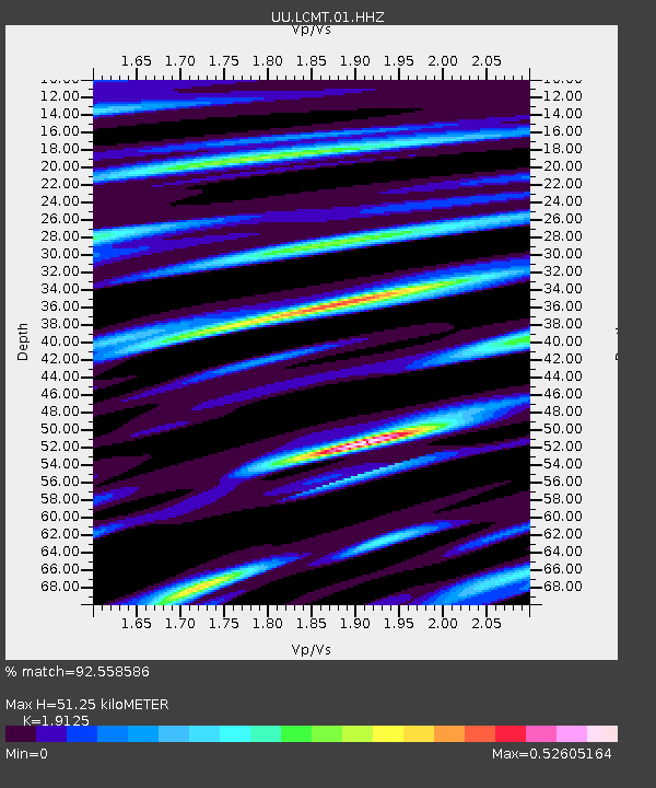
| Estimated Moho Depth: |
51.25 km |
| Estimated Crust Vp/Vs: |
1.91 |
| Assumed Crust Vp: |
6.194 km/s |
| Estimated Crust Vs: |
3.239 km/s |
| Estimated Crust Poisson's Ratio: |
0.31 |
|
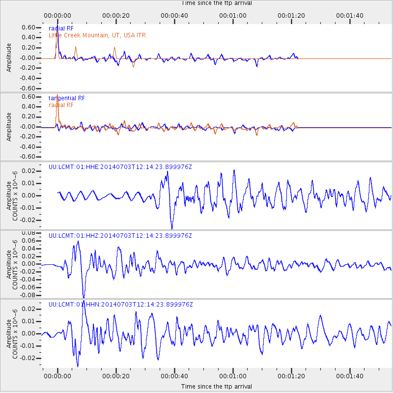
| Radial Match: |
92.558586 % |
| Radial Bump: |
283 |
| Transverse Match: |
80.381714 % |
| Transverse Bump: |
400 |
| SOD ConfigId: |
751272 |
| Insert Time: |
2014-07-17 13:05:38.950 +0000 |
| GWidth: |
2.5 |
| Max Bumps: |
400 |
| Tol: |
0.001 |
|
Signal To Noise
| Channel | StoN | STA | LTA |
| UU:LCMT:01:HHZ:20140703T12:14:23.899976Z | 7.6723914 | 1.3124755E-8 | 1.7106472E-9 |
| UU:LCMT:01:HHN:20140703T12:14:23.899976Z | 2.5301595 | 4.794172E-9 | 1.8948103E-9 |
| UU:LCMT:01:HHE:20140703T12:14:23.899976Z | 2.171552 | 4.7153437E-9 | 2.1714166E-9 |
| Arrivals |
| Ps | 7.9 SECOND |
| PpPs | 23 SECOND |
| PsPs/PpSs | 31 SECOND |


