You are here: Home > Network List > UW - Pacific Northwest Regional Seismic Network Stations List
> Station LRIV Port Angeles, WA, USA > Earthquake Result Viewer
LRIV Port Angeles, WA, USA - Earthquake Result Viewer
| Earthquake location: |
Komandorskiye Ostrova Region |
| Earthquake latitude/longitude: |
55.2/166.9 |
| Earthquake time(UTC): |
2014/07/03 (184) 12:05:22 GMT |
| Earthquake Depth: |
10 km |
| Earthquake Magnitude: |
5.9 MWP |
| Earthquake Catalog/Contributor: |
NEIC PDE/NEIC COMCAT |
|
| Network: |
UW Pacific Northwest Regional Seismic Network |
| Station: |
LRIV Port Angeles, WA, USA |
| Lat/Lon: |
48.06 N/123.50 W |
| Elevation: |
294 m |
|
| Distance: |
42.1 deg |
| Az: |
69.645 deg |
| Baz: |
306.767 deg |
| Ray Param: |
0.073363274 |
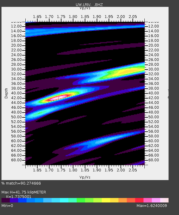
| Estimated Moho Depth: |
41.75 km |
| Estimated Crust Vp/Vs: |
1.74 |
| Assumed Crust Vp: |
6.566 km/s |
| Estimated Crust Vs: |
3.779 km/s |
| Estimated Crust Poisson's Ratio: |
0.25 |
|
| Radial Match: |
90.274666 % |
| Radial Bump: |
364 |
| Transverse Match: |
83.13607 % |
| Transverse Bump: |
400 |
| SOD ConfigId: |
751272 |
| Insert Time: |
2014-07-17 13:07:52.439 +0000 |
| GWidth: |
2.5 |
| Max Bumps: |
400 |
| Tol: |
0.001 |
|

Signal To Noise
| Channel | StoN | STA | LTA |
| UW:LRIV: :BHZ:20140703T12:12:44.109998Z | 7.46005 | 5.9059244E-7 | 7.916736E-8 |
| UW:LRIV: :BHN:20140703T12:12:44.109998Z | 1.6660504 | 2.2241666E-7 | 1.3349936E-7 |
| UW:LRIV: :BHE:20140703T12:12:44.109998Z | 1.5375385 | 1.9020585E-7 | 1.2370802E-7 |
| Arrivals |
| Ps | 5.0 SECOND |
| PpPs | 16 SECOND |
| PsPs/PpSs | 21 SECOND |


