You are here: Home > Network List > WY - Yellowstone Wyoming Seismic Network Stations List
> Station YHB Horse Butte YNP, MT, USA > Earthquake Result Viewer
YHB Horse Butte YNP, MT, USA - Earthquake Result Viewer
| Earthquake location: |
Komandorskiye Ostrova Region |
| Earthquake latitude/longitude: |
55.2/166.9 |
| Earthquake time(UTC): |
2014/07/03 (184) 12:05:22 GMT |
| Earthquake Depth: |
10 km |
| Earthquake Magnitude: |
5.9 MWP |
| Earthquake Catalog/Contributor: |
NEIC PDE/NEIC COMCAT |
|
| Network: |
WY Yellowstone Wyoming Seismic Network |
| Station: |
YHB Horse Butte YNP, MT, USA |
| Lat/Lon: |
44.75 N/111.20 W |
| Elevation: |
2167 m |
|
| Distance: |
50.8 deg |
| Az: |
65.615 deg |
| Baz: |
312.887 deg |
| Ray Param: |
0.067840345 |
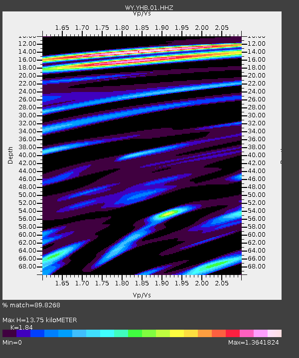
| Estimated Moho Depth: |
13.75 km |
| Estimated Crust Vp/Vs: |
1.84 |
| Assumed Crust Vp: |
6.35 km/s |
| Estimated Crust Vs: |
3.451 km/s |
| Estimated Crust Poisson's Ratio: |
0.29 |
|
| Radial Match: |
89.8268 % |
| Radial Bump: |
400 |
| Transverse Match: |
81.71849 % |
| Transverse Bump: |
400 |
| SOD ConfigId: |
751272 |
| Insert Time: |
2014-07-17 13:10:25.616 +0000 |
| GWidth: |
2.5 |
| Max Bumps: |
400 |
| Tol: |
0.001 |
|

Signal To Noise
| Channel | StoN | STA | LTA |
| WY:YHB:01:HHZ:20140703T12:13:51.914014Z | 7.951724 | 1.832555E-8 | 2.304601E-9 |
| WY:YHB:01:HHN:20140703T12:13:51.914014Z | 2.3499403 | 6.1407537E-9 | 2.613153E-9 |
| WY:YHB:01:HHE:20140703T12:13:51.914014Z | 8.493536 | 9.219492E-9 | 1.0854716E-9 |
| Arrivals |
| Ps | 1.9 SECOND |
| PpPs | 5.8 SECOND |
| PsPs/PpSs | 7.7 SECOND |


