You are here: Home > Network List > CI - Caltech Regional Seismic Network Stations List
> Station MPM Manuel Prospect Mine, California, USA > Earthquake Result Viewer
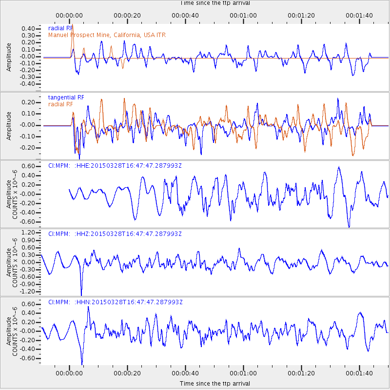
MPM Manuel Prospect Mine, California, USA - Earthquake Result Viewer
*The percent match for this event was below the threshold and hence no stack was calculated.
| Earthquake location: |
Northern Chile |
| Earthquake latitude/longitude: |
-22.2/-68.7 |
| Earthquake time(UTC): |
2015/03/28 (087) 16:36:52 GMT |
| Earthquake Depth: |
109 km |
| Earthquake Magnitude: |
6.0 MB |
| Earthquake Catalog/Contributor: |
NEIC PDE/NEIC COMCAT |
|
| Network: |
CI Caltech Regional Seismic Network |
| Station: |
MPM Manuel Prospect Mine, California, USA |
| Lat/Lon: |
36.06 N/117.49 W |
| Elevation: |
185 m |
|
| Distance: |
74.1 deg |
| Az: |
320.634 deg |
| Baz: |
133.496 deg |
| Ray Param: |
$rayparam |
*The percent match for this event was below the threshold and hence was not used in the summary stack. |
|
| Radial Match: |
65.006134 % |
| Radial Bump: |
400 |
| Transverse Match: |
70.24758 % |
| Transverse Bump: |
400 |
| SOD ConfigId: |
7422571 |
| Insert Time: |
2019-04-17 22:37:44.819 +0000 |
| GWidth: |
2.5 |
| Max Bumps: |
400 |
| Tol: |
0.001 |
|
Signal To Noise
| Channel | StoN | STA | LTA |
| CI:MPM: :HHZ:20150328T16:47:47.287993Z | 1.7086024 | 3.9244475E-7 | 2.2968757E-7 |
| CI:MPM: :HHN:20150328T16:47:47.287993Z | 1.9883987 | 2.8758737E-7 | 1.4463265E-7 |
| CI:MPM: :HHE:20150328T16:47:47.287993Z | 1.5440491 | 2.5679603E-7 | 1.6631337E-7 |
| Arrivals |
| Ps | |
| PpPs | |
| PsPs/PpSs | |


