You are here: Home > Network List > TA - USArray Transportable Network (new EarthScope stations) Stations List
> Station A04D Lummi Island, WA, USA > Earthquake Result Viewer
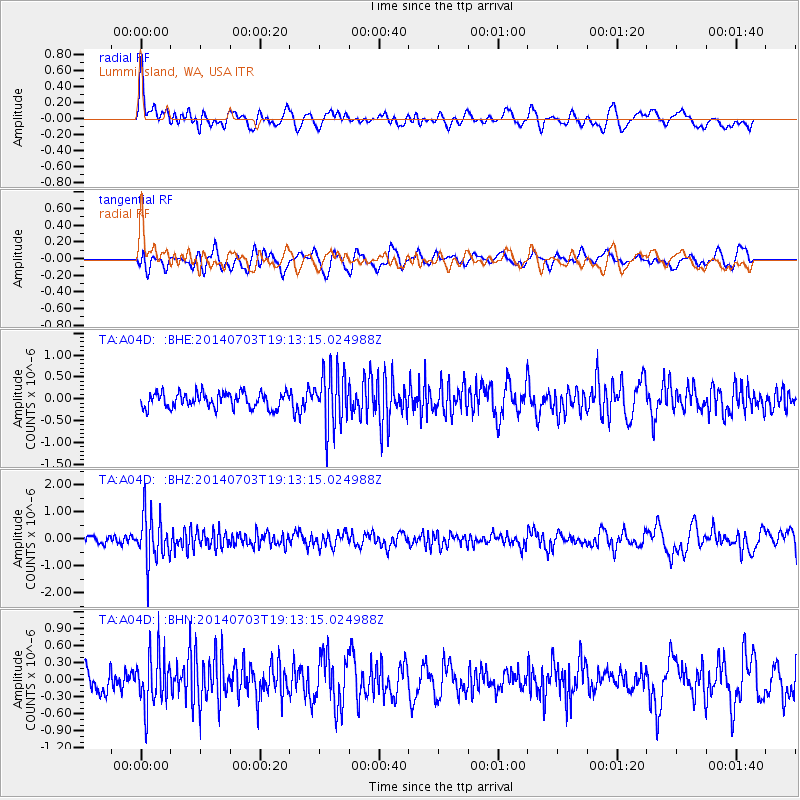
A04D Lummi Island, WA, USA - Earthquake Result Viewer
*The percent match for this event was below the threshold and hence no stack was calculated.
| Earthquake location: |
Rat Islands, Aleutian Islands |
| Earthquake latitude/longitude: |
52.1/178.5 |
| Earthquake time(UTC): |
2014/07/03 (184) 19:06:47 GMT |
| Earthquake Depth: |
104 km |
| Earthquake Magnitude: |
5.7 MWB, 5.6 MI |
| Earthquake Catalog/Contributor: |
NEIC PDE/NEIC COMCAT |
|
| Network: |
TA USArray Transportable Network (new EarthScope stations) |
| Station: |
A04D Lummi Island, WA, USA |
| Lat/Lon: |
48.72 N/122.71 W |
| Elevation: |
13 m |
|
| Distance: |
36.8 deg |
| Az: |
71.204 deg |
| Baz: |
298.071 deg |
| Ray Param: |
$rayparam |
*The percent match for this event was below the threshold and hence was not used in the summary stack. |
|
| Radial Match: |
54.821243 % |
| Radial Bump: |
400 |
| Transverse Match: |
49.988895 % |
| Transverse Bump: |
400 |
| SOD ConfigId: |
751272 |
| Insert Time: |
2014-07-17 19:51:55.240 +0000 |
| GWidth: |
2.5 |
| Max Bumps: |
400 |
| Tol: |
0.001 |
|
Signal To Noise
| Channel | StoN | STA | LTA |
| TA:A04D: :BHZ:20140703T19:13:15.024988Z | 7.812044 | 9.080388E-7 | 1.1623575E-7 |
| TA:A04D: :BHN:20140703T19:13:15.024988Z | 2.5484264 | 4.592163E-7 | 1.8019603E-7 |
| TA:A04D: :BHE:20140703T19:13:15.024988Z | 3.6888154 | 6.4057895E-7 | 1.7365439E-7 |
| Arrivals |
| Ps | |
| PpPs | |
| PsPs/PpSs | |


