You are here: Home > Network List > TA - USArray Transportable Network (new EarthScope stations) Stations List
> Station U40A Yellville, AR, USA > Earthquake Result Viewer
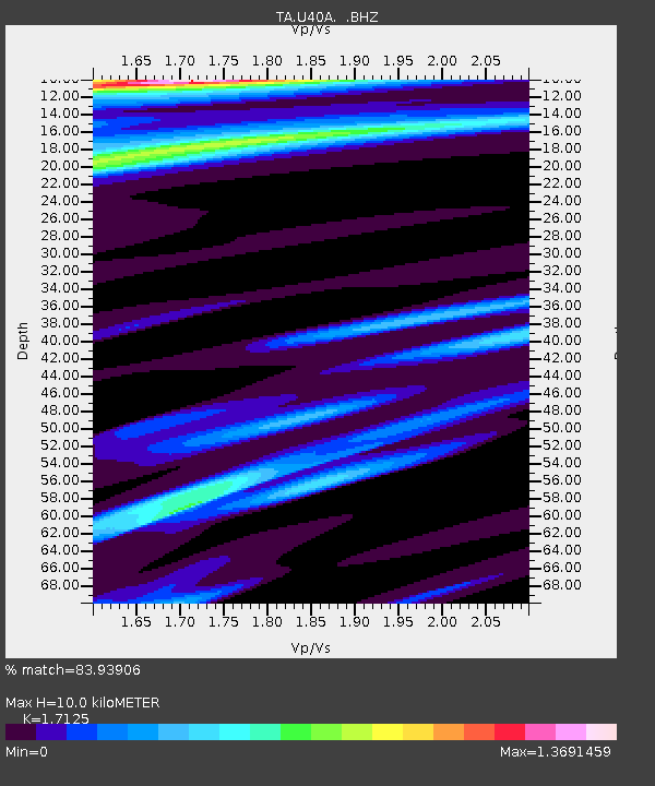
U40A Yellville, AR, USA - Earthquake Result Viewer
| Earthquake location: |
Rat Islands, Aleutian Islands |
| Earthquake latitude/longitude: |
52.1/178.5 |
| Earthquake time(UTC): |
2014/07/03 (184) 19:06:47 GMT |
| Earthquake Depth: |
104 km |
| Earthquake Magnitude: |
5.7 MWB, 5.6 MI |
| Earthquake Catalog/Contributor: |
NEIC PDE/NEIC COMCAT |
|
| Network: |
TA USArray Transportable Network (new EarthScope stations) |
| Station: |
U40A Yellville, AR, USA |
| Lat/Lon: |
36.36 N/92.85 W |
| Elevation: |
374 m |
|
| Distance: |
61.6 deg |
| Az: |
66.569 deg |
| Baz: |
315.445 deg |
| Ray Param: |
0.060492463 |
| Estimated Moho Depth: |
10.0 km |
| Estimated Crust Vp/Vs: |
1.71 |
| Assumed Crust Vp: |
6.53 km/s |
| Estimated Crust Vs: |
3.813 km/s |
| Estimated Crust Poisson's Ratio: |
0.24 |
|
| Radial Match: |
83.93906 % |
| Radial Bump: |
400 |
| Transverse Match: |
74.77771 % |
| Transverse Bump: |
400 |
| SOD ConfigId: |
751272 |
| Insert Time: |
2014-07-17 20:00:43.213 +0000 |
| GWidth: |
2.5 |
| Max Bumps: |
400 |
| Tol: |
0.001 |
|

Signal To Noise
| Channel | StoN | STA | LTA |
| TA:U40A: :BHZ:20140703T19:16:23.574976Z | 1.7727251 | 4.8920003E-7 | 2.7595934E-7 |
| TA:U40A: :BHN:20140703T19:16:23.574976Z | 2.1304529 | 3.9143282E-7 | 1.8373223E-7 |
| TA:U40A: :BHE:20140703T19:16:23.574976Z | 1.2152419 | 2.867081E-7 | 2.3592675E-7 |
| Arrivals |
| Ps | 1.1 SECOND |
| PpPs | 4.0 SECOND |
| PsPs/PpSs | 5.1 SECOND |


