You are here: Home > Network List > II - Global Seismograph Network (GSN - IRIS/IDA) Stations List
> Station SACV Santiago Island, Cape Verde > Earthquake Result Viewer
SACV Santiago Island, Cape Verde - Earthquake Result Viewer
| Earthquake location: |
North Of Honduras |
| Earthquake latitude/longitude: |
16.7/-86.2 |
| Earthquake time(UTC): |
2009/05/28 (148) 08:24:45 GMT |
| Earthquake Depth: |
10 km |
| Earthquake Magnitude: |
6.7 MB, 7.2 MS, 7.3 MW, 7.3 MW |
| Earthquake Catalog/Contributor: |
WHDF/NEIC |
|
| Network: |
II Global Seismograph Network (GSN - IRIS/IDA) |
| Station: |
SACV Santiago Island, Cape Verde |
| Lat/Lon: |
14.97 N/23.61 W |
| Elevation: |
387 m |
|
| Distance: |
60.0 deg |
| Az: |
82.112 deg |
| Baz: |
280.859 deg |
| Ray Param: |
0.061788075 |
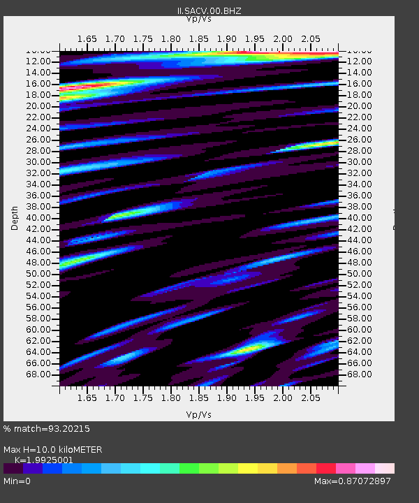
| Estimated Moho Depth: |
10.0 km |
| Estimated Crust Vp/Vs: |
1.99 |
| Assumed Crust Vp: |
4.082 km/s |
| Estimated Crust Vs: |
2.049 km/s |
| Estimated Crust Poisson's Ratio: |
0.33 |
|
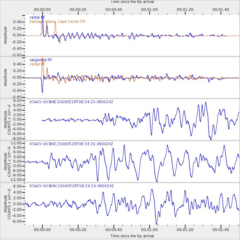
| Radial Match: |
93.20215 % |
| Radial Bump: |
400 |
| Transverse Match: |
89.09431 % |
| Transverse Bump: |
400 |
| SOD ConfigId: |
2648 |
| Insert Time: |
2010-03-01 23:47:35.766 +0000 |
| GWidth: |
2.5 |
| Max Bumps: |
400 |
| Tol: |
0.001 |
|
Signal To Noise
| Channel | StoN | STA | LTA |
| II:SACV:00:BHZ:20090528T08:34:20.980024Z | 6.4611235 | 1.8513821E-6 | 2.8654182E-7 |
| II:SACV:00:BHN:20090528T08:34:20.980024Z | 1.1449257 | 5.55424E-7 | 4.8511794E-7 |
| II:SACV:00:BHE:20090528T08:34:20.980024Z | 2.2788522 | 6.823398E-7 | 2.994226E-7 |
| Arrivals |
| Ps | 2.5 SECOND |
| PpPs | 7.2 SECOND |
| PsPs/PpSs | 9.7 SECOND |


