You are here: Home > Network List > US - United States National Seismic Network Stations List
> Station MNTX Cornudas Mountains, Texas, USA > Earthquake Result Viewer
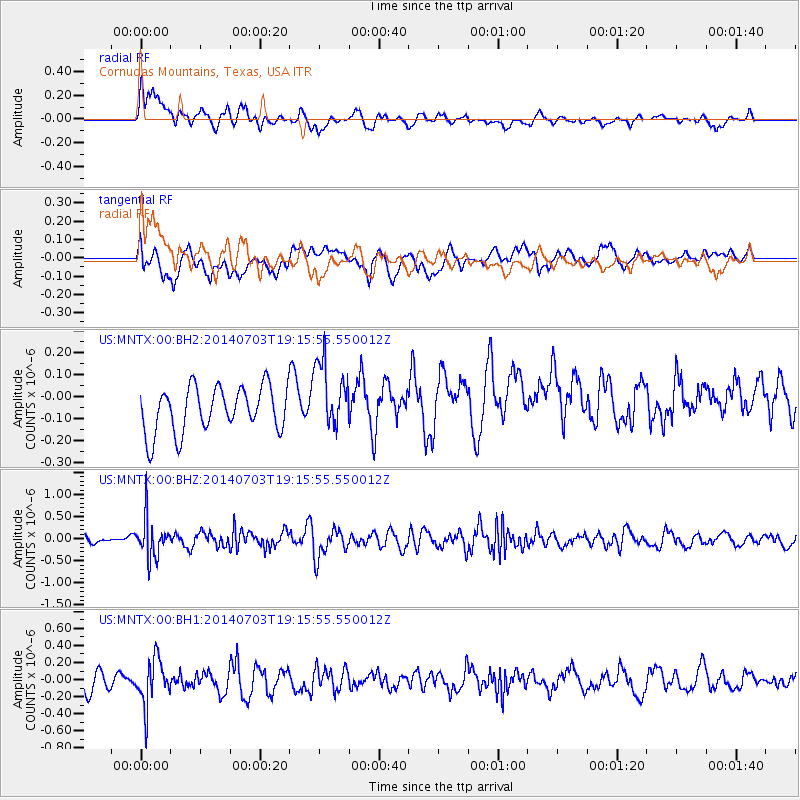
MNTX Cornudas Mountains, Texas, USA - Earthquake Result Viewer
*The percent match for this event was below the threshold and hence no stack was calculated.
| Earthquake location: |
Rat Islands, Aleutian Islands |
| Earthquake latitude/longitude: |
52.1/178.5 |
| Earthquake time(UTC): |
2014/07/03 (184) 19:06:47 GMT |
| Earthquake Depth: |
104 km |
| Earthquake Magnitude: |
5.7 MWB, 5.6 MI |
| Earthquake Catalog/Contributor: |
NEIC PDE/NEIC COMCAT |
|
| Network: |
US United States National Seismic Network |
| Station: |
MNTX Cornudas Mountains, Texas, USA |
| Lat/Lon: |
31.70 N/105.38 W |
| Elevation: |
404 m |
|
| Distance: |
57.5 deg |
| Az: |
78.904 deg |
| Baz: |
314.716 deg |
| Ray Param: |
$rayparam |
*The percent match for this event was below the threshold and hence was not used in the summary stack. |
|
| Radial Match: |
49.580784 % |
| Radial Bump: |
400 |
| Transverse Match: |
43.732296 % |
| Transverse Bump: |
400 |
| SOD ConfigId: |
751272 |
| Insert Time: |
2014-07-17 20:04:43.627 +0000 |
| GWidth: |
2.5 |
| Max Bumps: |
400 |
| Tol: |
0.001 |
|
Signal To Noise
| Channel | StoN | STA | LTA |
| US:MNTX:00:BHZ:20140703T19:15:55.550012Z | 3.297422 | 4.353334E-7 | 1.3202235E-7 |
| US:MNTX:00:BH1:20140703T19:15:55.550012Z | 2.3585281 | 2.6872118E-7 | 1.1393596E-7 |
| US:MNTX:00:BH2:20140703T19:15:55.550012Z | 1.5251796 | 1.5586136E-7 | 1.0219213E-7 |
| Arrivals |
| Ps | |
| PpPs | |
| PsPs/PpSs | |


