You are here: Home > Network List > II - Global Seismograph Network (GSN - IRIS/IDA) Stations List
> Station SACV Santiago Island, Cape Verde > Earthquake Result Viewer
SACV Santiago Island, Cape Verde - Earthquake Result Viewer
| Earthquake location: |
Lake Tanganyika Region |
| Earthquake latitude/longitude: |
-8.0/30.7 |
| Earthquake time(UTC): |
2000/10/02 (276) 02:25:31 GMT |
| Earthquake Depth: |
34 km |
| Earthquake Magnitude: |
6.1 MB, 6.7 MS, 6.5 MW, 6.2 ME |
| Earthquake Catalog/Contributor: |
WHDF/NEIC |
|
| Network: |
II Global Seismograph Network (GSN - IRIS/IDA) |
| Station: |
SACV Santiago Island, Cape Verde |
| Lat/Lon: |
14.97 N/23.61 W |
| Elevation: |
387 m |
|
| Distance: |
58.5 deg |
| Az: |
292.922 deg |
| Baz: |
109.288 deg |
| Ray Param: |
0.062764816 |
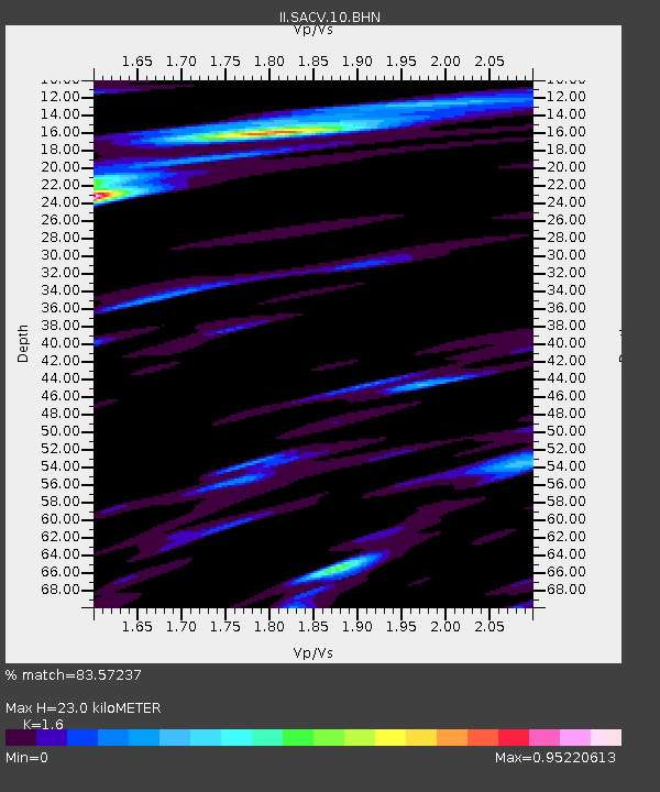
| Estimated Moho Depth: |
23.0 km |
| Estimated Crust Vp/Vs: |
1.60 |
| Assumed Crust Vp: |
4.082 km/s |
| Estimated Crust Vs: |
2.551 km/s |
| Estimated Crust Poisson's Ratio: |
0.18 |
|
| Radial Match: |
83.57237 % |
| Radial Bump: |
400 |
| Transverse Match: |
59.375114 % |
| Transverse Bump: |
400 |
| SOD ConfigId: |
3744 |
| Insert Time: |
2010-03-01 23:47:41.983 +0000 |
| GWidth: |
2.5 |
| Max Bumps: |
400 |
| Tol: |
0.001 |
|
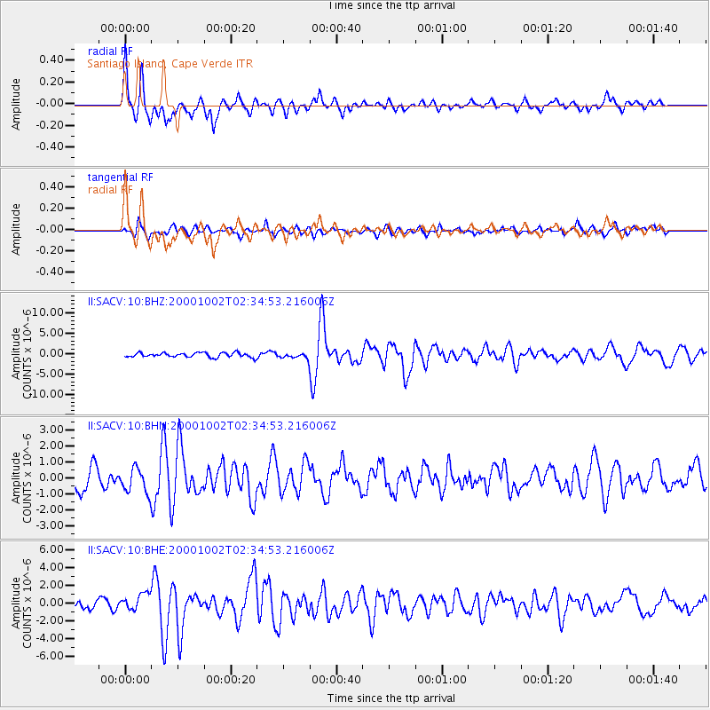
Signal To Noise
| Channel | StoN | STA | LTA |
| II:SACV:10:BHN:20001002T02:34:53.216006Z | 1.1495839 | 7.865476E-7 | 6.84202E-7 |
| II:SACV:10:BHE:20001002T02:34:53.216006Z | 2.3795395 | 9.3338076E-7 | 3.9225267E-7 |
| II:SACV:10:BHZ:20001002T02:34:53.216006Z | 1.2447442 | 6.778046E-7 | 5.445333E-7 |
| Arrivals |
| Ps | 3.5 SECOND |
| PpPs | 14 SECOND |
| PsPs/PpSs | 18 SECOND |


