You are here: Home > Network List > UU - University of Utah Regional Network Stations List
> Station KNB Kanab, UT, USA > Earthquake Result Viewer
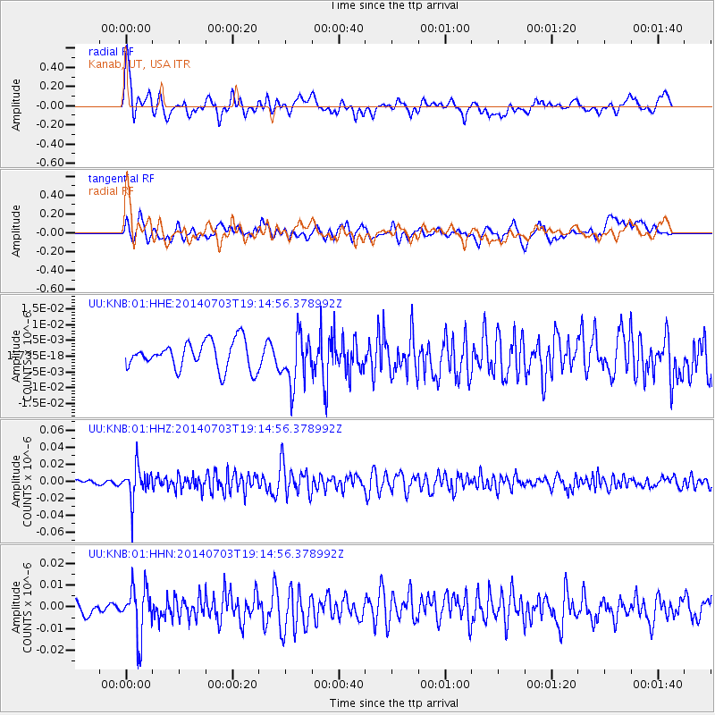
KNB Kanab, UT, USA - Earthquake Result Viewer
*The percent match for this event was below the threshold and hence no stack was calculated.
| Earthquake location: |
Rat Islands, Aleutian Islands |
| Earthquake latitude/longitude: |
52.1/178.5 |
| Earthquake time(UTC): |
2014/07/03 (184) 19:06:47 GMT |
| Earthquake Depth: |
104 km |
| Earthquake Magnitude: |
5.7 MWB, 5.6 MI |
| Earthquake Catalog/Contributor: |
NEIC PDE/NEIC COMCAT |
|
| Network: |
UU University of Utah Regional Network |
| Station: |
KNB Kanab, UT, USA |
| Lat/Lon: |
37.02 N/112.82 W |
| Elevation: |
1715 m |
|
| Distance: |
49.4 deg |
| Az: |
79.26 deg |
| Baz: |
310.74 deg |
| Ray Param: |
$rayparam |
*The percent match for this event was below the threshold and hence was not used in the summary stack. |
|
| Radial Match: |
76.84958 % |
| Radial Bump: |
400 |
| Transverse Match: |
61.24357 % |
| Transverse Bump: |
400 |
| SOD ConfigId: |
751272 |
| Insert Time: |
2014-07-17 20:06:41.524 +0000 |
| GWidth: |
2.5 |
| Max Bumps: |
400 |
| Tol: |
0.001 |
|
Signal To Noise
| Channel | StoN | STA | LTA |
| UU:KNB:01:HHZ:20140703T19:14:56.378992Z | 6.3404317 | 1.9651196E-8 | 3.0993468E-9 |
| UU:KNB:01:HHN:20140703T19:14:56.378992Z | 2.8405657 | 1.1581265E-8 | 4.0770978E-9 |
| UU:KNB:01:HHE:20140703T19:14:56.378992Z | 1.8067234 | 7.921728E-9 | 4.3845825E-9 |
| Arrivals |
| Ps | |
| PpPs | |
| PsPs/PpSs | |


