You are here: Home > Network List > UW - Pacific Northwest Regional Seismic Network Stations List
> Station MRBL Marblemount, WA, USA > Earthquake Result Viewer
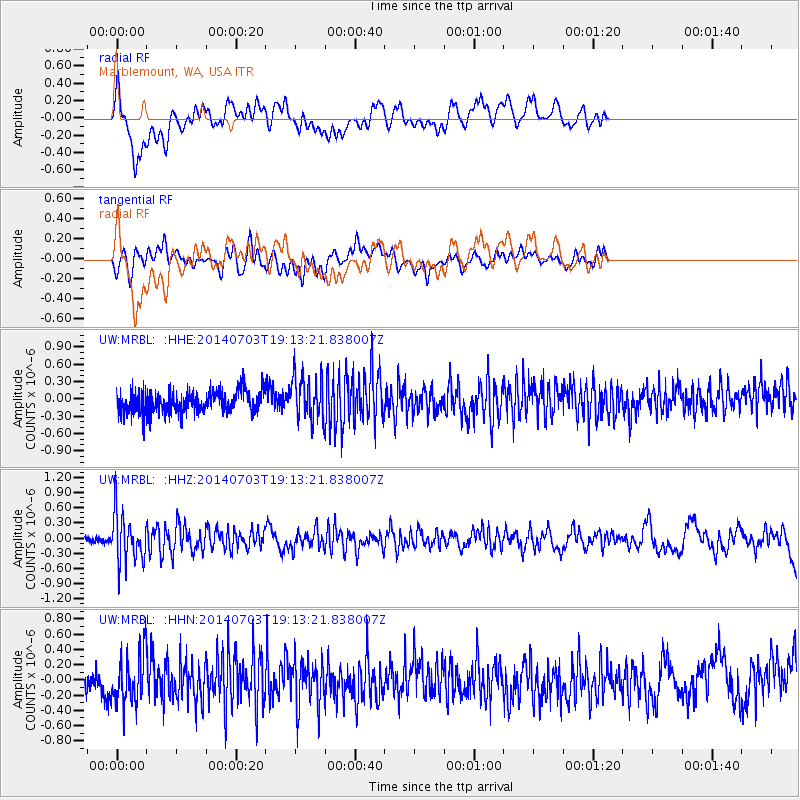
MRBL Marblemount, WA, USA - Earthquake Result Viewer
*The percent match for this event was below the threshold and hence no stack was calculated.
| Earthquake location: |
Rat Islands, Aleutian Islands |
| Earthquake latitude/longitude: |
52.1/178.5 |
| Earthquake time(UTC): |
2014/07/03 (184) 19:06:47 GMT |
| Earthquake Depth: |
104 km |
| Earthquake Magnitude: |
5.7 MWB, 5.6 MI |
| Earthquake Catalog/Contributor: |
NEIC PDE/NEIC COMCAT |
|
| Network: |
UW Pacific Northwest Regional Seismic Network |
| Station: |
MRBL Marblemount, WA, USA |
| Lat/Lon: |
48.52 N/121.48 W |
| Elevation: |
75 m |
|
| Distance: |
37.6 deg |
| Az: |
70.86 deg |
| Baz: |
298.711 deg |
| Ray Param: |
$rayparam |
*The percent match for this event was below the threshold and hence was not used in the summary stack. |
|
| Radial Match: |
63.13505 % |
| Radial Bump: |
400 |
| Transverse Match: |
52.547268 % |
| Transverse Bump: |
400 |
| SOD ConfigId: |
751272 |
| Insert Time: |
2014-07-17 20:09:11.870 +0000 |
| GWidth: |
2.5 |
| Max Bumps: |
400 |
| Tol: |
0.001 |
|
Signal To Noise
| Channel | StoN | STA | LTA |
| UW:MRBL: :HHZ:20140703T19:13:21.838007Z | 5.159801 | 4.7768566E-7 | 9.257831E-8 |
| UW:MRBL: :HHN:20140703T19:13:21.838007Z | 1.6666672 | 3.1697186E-7 | 1.9018304E-7 |
| UW:MRBL: :HHE:20140703T19:13:21.838007Z | 1.9782621 | 3.7258627E-7 | 1.8834021E-7 |
| Arrivals |
| Ps | |
| PpPs | |
| PsPs/PpSs | |


