You are here: Home > Network List > AU - Australian Seismological Centre Stations List
> Station CTA Charters Towers, Queensland > Earthquake Result Viewer
CTA Charters Towers, Queensland - Earthquake Result Viewer
| Earthquake location: |
Kermadec Islands Region |
| Earthquake latitude/longitude: |
-30.5/-176.5 |
| Earthquake time(UTC): |
2014/07/03 (184) 19:50:05 GMT |
| Earthquake Depth: |
20 km |
| Earthquake Magnitude: |
6.3 MWB, 6.6 MI |
| Earthquake Catalog/Contributor: |
NEIC PDE/NEIC COMCAT |
|
| Network: |
AU Australian Seismological Centre |
| Station: |
CTA Charters Towers, Queensland |
| Lat/Lon: |
20.09 S/146.25 E |
| Elevation: |
426 m |
|
| Distance: |
35.1 deg |
| Az: |
278.378 deg |
| Baz: |
114.743 deg |
| Ray Param: |
0.0773863 |
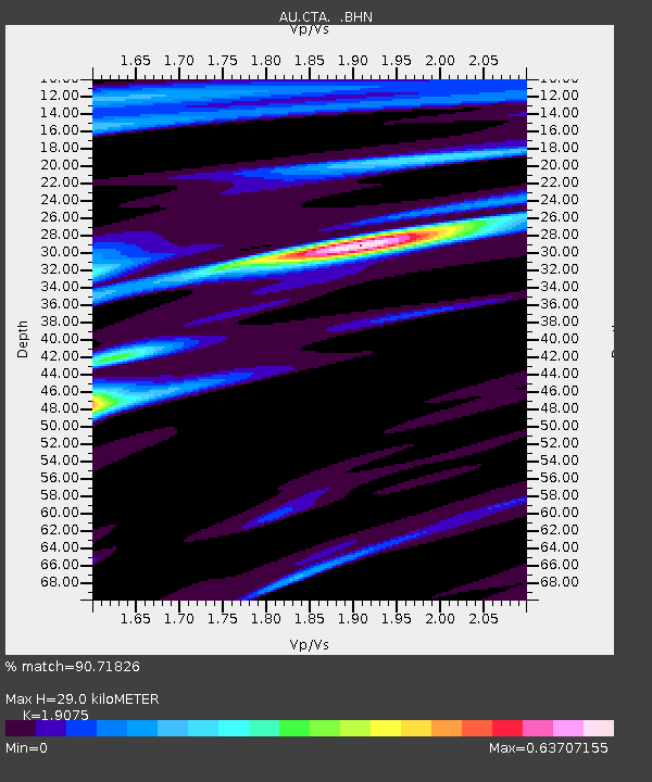
| Estimated Moho Depth: |
29.0 km |
| Estimated Crust Vp/Vs: |
1.91 |
| Assumed Crust Vp: |
6.522 km/s |
| Estimated Crust Vs: |
3.419 km/s |
| Estimated Crust Poisson's Ratio: |
0.31 |
|
| Radial Match: |
90.71826 % |
| Radial Bump: |
268 |
| Transverse Match: |
79.28694 % |
| Transverse Bump: |
400 |
| SOD ConfigId: |
751272 |
| Insert Time: |
2014-07-17 20:20:35.833 +0000 |
| GWidth: |
2.5 |
| Max Bumps: |
400 |
| Tol: |
0.001 |
|

Signal To Noise
| Channel | StoN | STA | LTA |
| AU:CTA: :BHZ:20140703T19:56:26.024985Z | 3.6284633 | 1.4564448E-6 | 4.013944E-7 |
| AU:CTA: :BHN:20140703T19:56:26.024985Z | 1.3987255 | 3.2519617E-7 | 2.3249464E-7 |
| AU:CTA: :BHE:20140703T19:56:26.024985Z | 3.82138 | 9.20448E-7 | 2.4086796E-7 |
| Arrivals |
| Ps | 4.3 SECOND |
| PpPs | 12 SECOND |
| PsPs/PpSs | 16 SECOND |


