You are here: Home > Network List > TA - USArray Transportable Network (new EarthScope stations) Stations List
> Station MSTX Muleshoe, TX, USA > Earthquake Result Viewer
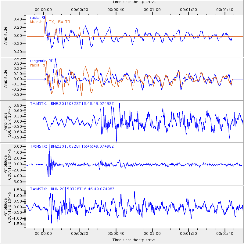
MSTX Muleshoe, TX, USA - Earthquake Result Viewer
*The percent match for this event was below the threshold and hence no stack was calculated.
| Earthquake location: |
Northern Chile |
| Earthquake latitude/longitude: |
-22.2/-68.7 |
| Earthquake time(UTC): |
2015/03/28 (087) 16:36:52 GMT |
| Earthquake Depth: |
109 km |
| Earthquake Magnitude: |
6.0 MB |
| Earthquake Catalog/Contributor: |
NEIC PDE/NEIC COMCAT |
|
| Network: |
TA USArray Transportable Network (new EarthScope stations) |
| Station: |
MSTX Muleshoe, TX, USA |
| Lat/Lon: |
33.97 N/102.77 W |
| Elevation: |
1167 m |
|
| Distance: |
64.6 deg |
| Az: |
328.941 deg |
| Baz: |
144.879 deg |
| Ray Param: |
$rayparam |
*The percent match for this event was below the threshold and hence was not used in the summary stack. |
|
| Radial Match: |
58.92763 % |
| Radial Bump: |
400 |
| Transverse Match: |
73.28598 % |
| Transverse Bump: |
400 |
| SOD ConfigId: |
7422571 |
| Insert Time: |
2019-04-17 22:43:18.520 +0000 |
| GWidth: |
2.5 |
| Max Bumps: |
400 |
| Tol: |
0.001 |
|
Signal To Noise
| Channel | StoN | STA | LTA |
| TA:MSTX: :BHZ:20150328T16:46:49.07498Z | 13.550851 | 2.205553E-6 | 1.6276122E-7 |
| TA:MSTX: :BHN:20150328T16:46:49.07498Z | 3.2724595 | 5.463483E-7 | 1.6695343E-7 |
| TA:MSTX: :BHE:20150328T16:46:49.07498Z | 2.1362016 | 3.6754804E-7 | 1.7205682E-7 |
| Arrivals |
| Ps | |
| PpPs | |
| PsPs/PpSs | |


