You are here: Home > Network List > II - Global Seismograph Network (GSN - IRIS/IDA) Stations List
> Station ESK Eskdalemuir, Scotland, UK > Earthquake Result Viewer
ESK Eskdalemuir, Scotland, UK - Earthquake Result Viewer
| Earthquake location: |
Northwest Of Kuril Islands |
| Earthquake latitude/longitude: |
47.8/146.2 |
| Earthquake time(UTC): |
2002/11/17 (321) 04:53:53 GMT |
| Earthquake Depth: |
459 km |
| Earthquake Magnitude: |
7.3 MW, 7.3 MW |
| Earthquake Catalog/Contributor: |
WHDF/NEIC |
|
| Network: |
II Global Seismograph Network (GSN - IRIS/IDA) |
| Station: |
ESK Eskdalemuir, Scotland, UK |
| Lat/Lon: |
55.32 N/3.20 W |
| Elevation: |
242 m |
|
| Distance: |
74.1 deg |
| Az: |
342.393 deg |
| Baz: |
20.892 deg |
| Ray Param: |
0.05117295 |
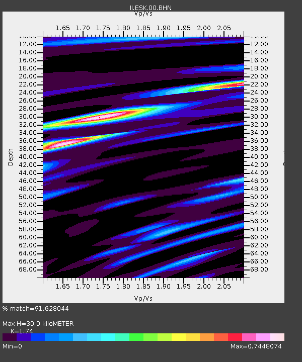
| Estimated Moho Depth: |
30.0 km |
| Estimated Crust Vp/Vs: |
1.74 |
| Assumed Crust Vp: |
6.276 km/s |
| Estimated Crust Vs: |
3.607 km/s |
| Estimated Crust Poisson's Ratio: |
0.25 |
|
| Radial Match: |
91.628044 % |
| Radial Bump: |
372 |
| Transverse Match: |
70.767586 % |
| Transverse Bump: |
400 |
| SOD ConfigId: |
4714 |
| Insert Time: |
2010-03-01 23:48:43.294 +0000 |
| GWidth: |
2.5 |
| Max Bumps: |
400 |
| Tol: |
0.001 |
|

Signal To Noise
| Channel | StoN | STA | LTA |
| II:ESK:00:BHN:20021117T05:04:10.547996Z | 14.3419895 | 4.011117E-6 | 2.796765E-7 |
| II:ESK:00:BHE:20021117T05:04:10.547996Z | 6.4270296 | 2.098742E-6 | 3.265493E-7 |
| II:ESK:00:BHZ:20021117T05:04:10.547019Z | 31.834768 | 1.0477529E-5 | 3.291222E-7 |
| Arrivals |
| Ps | 3.6 SECOND |
| PpPs | 13 SECOND |
| PsPs/PpSs | 16 SECOND |


