You are here: Home > Network List > GS - US Geological Survey Networks Stations List
> Station ID03 East of Rte 461 near Challis, ID, USA > Earthquake Result Viewer
ID03 East of Rte 461 near Challis, ID, USA - Earthquake Result Viewer
| Earthquake location: |
Kermadec Islands Region |
| Earthquake latitude/longitude: |
-30.5/-176.5 |
| Earthquake time(UTC): |
2014/07/03 (184) 19:50:05 GMT |
| Earthquake Depth: |
20 km |
| Earthquake Magnitude: |
6.3 MWB, 6.6 MI |
| Earthquake Catalog/Contributor: |
NEIC PDE/NEIC COMCAT |
|
| Network: |
GS US Geological Survey Networks |
| Station: |
ID03 East of Rte 461 near Challis, ID, USA |
| Lat/Lon: |
44.45 N/113.88 W |
| Elevation: |
1878 m |
|
| Distance: |
93.9 deg |
| Az: |
39.614 deg |
| Baz: |
230.191 deg |
| Ray Param: |
0.041151598 |
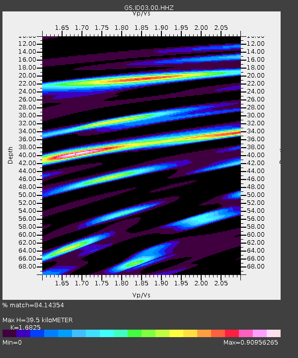
| Estimated Moho Depth: |
39.5 km |
| Estimated Crust Vp/Vs: |
1.68 |
| Assumed Crust Vp: |
6.577 km/s |
| Estimated Crust Vs: |
3.909 km/s |
| Estimated Crust Poisson's Ratio: |
0.23 |
|
| Radial Match: |
84.14354 % |
| Radial Bump: |
400 |
| Transverse Match: |
75.19936 % |
| Transverse Bump: |
400 |
| SOD ConfigId: |
751272 |
| Insert Time: |
2014-07-17 20:30:12.305 +0000 |
| GWidth: |
2.5 |
| Max Bumps: |
400 |
| Tol: |
0.001 |
|

Signal To Noise
| Channel | StoN | STA | LTA |
| GS:ID03:00:HHZ:20140703T20:02:49.698997Z | 26.527605 | 1.7198041E-6 | 6.4830736E-8 |
| GS:ID03:00:HH1:20140703T20:02:49.698997Z | 4.5095654 | 2.6489747E-7 | 5.874124E-8 |
| GS:ID03:00:HH2:20140703T20:02:49.698997Z | 4.6551647 | 4.4265082E-7 | 9.508811E-8 |
| Arrivals |
| Ps | 4.2 SECOND |
| PpPs | 16 SECOND |
| PsPs/PpSs | 20 SECOND |


