You are here: Home > Network List > IW - Intermountain West Stations List
> Station SMCO Snowmass, Colorado, USA > Earthquake Result Viewer
SMCO Snowmass, Colorado, USA - Earthquake Result Viewer
| Earthquake location: |
Kermadec Islands Region |
| Earthquake latitude/longitude: |
-30.5/-176.5 |
| Earthquake time(UTC): |
2014/07/03 (184) 19:50:05 GMT |
| Earthquake Depth: |
20 km |
| Earthquake Magnitude: |
6.3 MWB, 6.6 MI |
| Earthquake Catalog/Contributor: |
NEIC PDE/NEIC COMCAT |
|
| Network: |
IW Intermountain West |
| Station: |
SMCO Snowmass, Colorado, USA |
| Lat/Lon: |
39.18 N/106.97 W |
| Elevation: |
3435 m |
|
| Distance: |
94.8 deg |
| Az: |
46.958 deg |
| Baz: |
234.224 deg |
| Ray Param: |
0.04094476 |
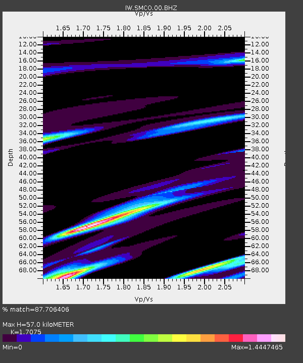
| Estimated Moho Depth: |
57.0 km |
| Estimated Crust Vp/Vs: |
1.71 |
| Assumed Crust Vp: |
6.306 km/s |
| Estimated Crust Vs: |
3.693 km/s |
| Estimated Crust Poisson's Ratio: |
0.24 |
|
| Radial Match: |
87.706406 % |
| Radial Bump: |
400 |
| Transverse Match: |
54.06956 % |
| Transverse Bump: |
400 |
| SOD ConfigId: |
751272 |
| Insert Time: |
2014-07-17 20:35:17.041 +0000 |
| GWidth: |
2.5 |
| Max Bumps: |
400 |
| Tol: |
0.001 |
|

Signal To Noise
| Channel | StoN | STA | LTA |
| IW:SMCO:00:BHZ:20140703T20:02:53.615012Z | 0.7279514 | 1.3271636E-9 | 1.8231487E-9 |
| IW:SMCO:00:BH1:20140703T20:02:53.615012Z | 0.74579406 | 2.2078628E-9 | 2.960419E-9 |
| IW:SMCO:00:BH2:20140703T20:02:53.615012Z | 0.9244388 | 2.0272075E-9 | 2.192906E-9 |
| Arrivals |
| Ps | 6.5 SECOND |
| PpPs | 24 SECOND |
| PsPs/PpSs | 31 SECOND |


